
 Meteo4you
strong El Niño 2015 - 2016 and its impacts in Europe
Pagina 9 di 18 •  1 ... 6 ... 8, 9, 10 ... 13 ... 18
Re: strong El Niño 2015 - 2016 and its impacts in Europe
Da 2210Gino57 Mer Nov 18, 2015 4:20 pm
che per fine novembre 2015
possibile split del polar vortex
wave1 and wave2 activity
general patterns precede each type
of polar vortex disruption
which was very interesting
current patterns look very similar
to what happens prior to a splitting event

2210Gino57- Messaggi : 5956
Data d'iscrizione : 29.10.15
Età : 66
Località : CH - 6044 LU 620 m s.l.m. Sicily 96010 Buccheri SR 820 m s.l.m. near M. Lauro Radar Sicily
Re: strong El Niño 2015 - 2016 and its impacts in Europe
Da 2210Gino57 Mer Nov 18, 2015 4:55 pm

ECMWF

alpine regions ... la -20°C ~
snow cover ... snow depth
2210Gino57- Messaggi : 5956
Data d'iscrizione : 29.10.15
Età : 66
Località : CH - 6044 LU 620 m s.l.m. Sicily 96010 Buccheri SR 820 m s.l.m. near M. Lauro Radar Sicily
Re: strong El Niño 2015 - 2016 and its impacts in Europe
Da WeatherRegime Mer Nov 18, 2015 5:45 pm
2210Gino57 ha scritto:come accennato vi ricordo
che per fine novembre 2015
possibile split del polar vortex
wave1 and wave2 activity
general patterns precede each type
of polar vortex disruption
which was very interesting
current patterns look very similar
to what happens prior to a splitting event
io vedendo gli ultimi run sto comicniando seriamente a pensare che l'approfondimento Stratosferico di questi ultimi giorni andrà a riperquotersi fino alla Troposfera.
al momento i GM faticano ad inquadrare un vero disturbo da parte delle Wave, viene visionata una 1Wave convergente al Polo ma scarsamente intrusiva, non vorrei provocasse quella chiusura che alcuni modelli cominciano a proporre maggiormente.

WeatherRegime- Messaggi : 4401
Data d'iscrizione : 15.10.15
Età : 33
Località : cantù
Re: strong El Niño 2015 - 2016 and its impacts in Europe
Da 2210Gino57 Mer Nov 18, 2015 5:56 pm
da non fraintendere ...
possibile pure che nella 1a decade di dicembre 2015
ci possa essere altra ( altre ) belle discese di aria fredda polare
volevo solo fare intendere che il PV viene circondato da H ( SSW )
vedi ad esempio da giorni over il Belarus la mega SH
2210Gino57- Messaggi : 5956
Data d'iscrizione : 29.10.15
Età : 66
Località : CH - 6044 LU 620 m s.l.m. Sicily 96010 Buccheri SR 820 m s.l.m. near M. Lauro Radar Sicily
Re: strong El Niño 2015 - 2016 and its impacts in Europe
Da WeatherRegime Mer Nov 18, 2015 6:01 pm
WeatherRegime- Messaggi : 4401
Data d'iscrizione : 15.10.15
Età : 33
Località : cantù
Re: strong El Niño 2015 - 2016 and its impacts in Europe
Da 2210Gino57 Mer Nov 18, 2015 6:15 pm
da monitorare e soprattutto
da prendere con le pinze
ma ... dipende tutto dai PFJ

freccia rossa => H ... freccia celeste = L
da notare la mega siberian high
purtroppo il nuovo run è in elaborazione
il modello della NOAA NCEP GFS vede caldo alias High Pressure
ma fino ad inizio dicembre 2015 può cambiare parecchie volte
2210Gino57- Messaggi : 5956
Data d'iscrizione : 29.10.15
Età : 66
Località : CH - 6044 LU 620 m s.l.m. Sicily 96010 Buccheri SR 820 m s.l.m. near M. Lauro Radar Sicily
Re: strong El Niño 2015 - 2016 and its impacts in Europe
Da 2210Gino57 Mer Nov 18, 2015 7:00 pm
we do seem to have some hybrid El Niño ... La Niña signals
coming along what with the change in AAM
that the GEFS has been toying with
what on earth is going on there ?
an extreme spike in AAM which i have come
to know as a signature mountain torque events
but this was not at all predicted
as of my last check on monday 23.11.2015
are we looking at errors here or is the atmosphere
genuinely going that far beyond what was expected ?
interesting to see the AAM now looking to perform
another cycle just above neutral rather than going
straight to negative
no wonder we have seen the notion of a second bout
of NW to N winds put back to later next week
as there's less of a signal
for amplification US - Atlantic than there was
but of course this resistence from the El Niño background
is potentially a very good thing for continued wave1 activity
even as wave 2 gets underway building and sustaining
a pinch on the vortex
admittedly the 06z GFS det. made a bit of a mess
of it late on in the run but the theme
is certainly there for the taking
with the opposing forces battling out and global patterns
leaning one way only to wobble back the other
the Azores - Euro High may be moving about rather
a lot in the next few weeks !
AAM => Atmospheric Angular Momentum
2210Gino57- Messaggi : 5956
Data d'iscrizione : 29.10.15
Età : 66
Località : CH - 6044 LU 620 m s.l.m. Sicily 96010 Buccheri SR 820 m s.l.m. near M. Lauro Radar Sicily
Re: strong El Niño 2015 - 2016 and its impacts in Europe
Da 2210Gino57 Mer Nov 18, 2015 7:10 pm
2210Gino57 ha scritto:se ho visto bene dai modelli ( nuovo run )
anticipano la saccatura prevista per il 23.11.2015
concordate ?
2210Gino57- Messaggi : 5956
Data d'iscrizione : 29.10.15
Età : 66
Località : CH - 6044 LU 620 m s.l.m. Sicily 96010 Buccheri SR 820 m s.l.m. near M. Lauro Radar Sicily
Re: strong El Niño 2015 - 2016 and its impacts in Europe
Da WeatherRegime Mer Nov 18, 2015 8:17 pm
WeatherRegime- Messaggi : 4401
Data d'iscrizione : 15.10.15
Età : 33
Località : cantù
Re: strong El Niño 2015 - 2016 and its impacts in Europe
Da 2210Gino57 Mer Nov 18, 2015 8:35 pm
prevede neve ( ? )
per la svizzera neve assicurata
quota neve ( 800 m - 500 m )
e che poi scende fino in pianura

colore grigio => neve ... da notare la wave2 ( rosa )
===
GFS NCEP NOAA

andiamo bene ...
===
Attenzione !
fortissimo Jet Streak da NO verso SE

jet stream ... jet streak

il rosso sono i jet streak
2210Gino57- Messaggi : 5956
Data d'iscrizione : 29.10.15
Età : 66
Località : CH - 6044 LU 620 m s.l.m. Sicily 96010 Buccheri SR 820 m s.l.m. near M. Lauro Radar Sicily
Re: strong El Niño 2015 - 2016 and its impacts in Europe
Da 2210Gino57 Mer Nov 18, 2015 10:15 pm
i miei Thread ed il suo contenuto
lo sapevo e me lo immaginavo già da tempo
quindi se da ora in poi qualcosa non la comprendete
fatemi domande domande domande ...
io sono pronto a rispondervi
===
ecco il motivo della Neve in Svizzera
vedi i Jet Stream ... Jet Streak ( in rosso )
precisamente sono i PFJ
PFJ => PolarFrontJetstream


2210Gino57- Messaggi : 5956
Data d'iscrizione : 29.10.15
Età : 66
Località : CH - 6044 LU 620 m s.l.m. Sicily 96010 Buccheri SR 820 m s.l.m. near M. Lauro Radar Sicily

2210Gino57- Messaggi : 5956
Data d'iscrizione : 29.10.15
Età : 66
Località : CH - 6044 LU 620 m s.l.m. Sicily 96010 Buccheri SR 820 m s.l.m. near M. Lauro Radar Sicily
Re: strong El Niño 2015 - 2016 and its impacts in Europe
Da 2210Gino57 Mer Nov 18, 2015 10:45 pm
nessuno ne discute ...
Siberian High ( SH )
Belarus
mega

2210Gino57- Messaggi : 5956
Data d'iscrizione : 29.10.15
Età : 66
Località : CH - 6044 LU 620 m s.l.m. Sicily 96010 Buccheri SR 820 m s.l.m. near M. Lauro Radar Sicily
Re: strong El Niño 2015 - 2016 and its impacts in Europe
Da 2210Gino57 Mer Nov 18, 2015 10:50 pm
cantone di lucerna
dove abito io
Lunedì 23.11.2015 sera notte ... i primi -8°C
Temp odierne sui +5°C ... povero me ... caldofilo
2210Gino57- Messaggi : 5956
Data d'iscrizione : 29.10.15
Età : 66
Località : CH - 6044 LU 620 m s.l.m. Sicily 96010 Buccheri SR 820 m s.l.m. near M. Lauro Radar Sicily
Re: strong El Niño 2015 - 2016 and its impacts in Europe
Da 2210Gino57 Mer Nov 18, 2015 11:10 pm
alpine regions
next +144 h

2210Gino57- Messaggi : 5956
Data d'iscrizione : 29.10.15
Età : 66
Località : CH - 6044 LU 620 m s.l.m. Sicily 96010 Buccheri SR 820 m s.l.m. near M. Lauro Radar Sicily
Re: strong El Niño 2015 - 2016 and its impacts in Europe
Da 2210Gino57 Mer Nov 18, 2015 11:25 pm
ve ne ho accennato
omega block
la omega block di cui vi ho accennato
giorni fa formatasi in atlantico
si è ora pian piano spostata causa i PFJ
alle nostre latitudini ... ed ecco il risultato
PFJ => PolarFrontJetstream
A => H delle Azzorre in espansione verso N ( detto pure Ridge )
B => L in discesa verso S ( detto pure Trough )

2210Gino57- Messaggi : 5956
Data d'iscrizione : 29.10.15
Età : 66
Località : CH - 6044 LU 620 m s.l.m. Sicily 96010 Buccheri SR 820 m s.l.m. near M. Lauro Radar Sicily
Re: strong El Niño 2015 - 2016 and its impacts in Europe
Da 2210Gino57 Gio Nov 19, 2015 11:05 am

2210Gino57- Messaggi : 5956
Data d'iscrizione : 29.10.15
Età : 66
Località : CH - 6044 LU 620 m s.l.m. Sicily 96010 Buccheri SR 820 m s.l.m. near M. Lauro Radar Sicily
Re: strong El Niño 2015 - 2016 and its impacts in Europe
Da 2210Gino57 Gio Nov 19, 2015 12:00 pm
central Europe

here are latest model guidance for the polar outbreak
coming into central europe this weekend
some impressive anomalies are expected
ultimo modello ECMWF per lo scoppio polare
che avanza in europa centrale
per questo fine settimana
sono attesi alcune anomalie impressionanti
2210Gino57- Messaggi : 5956
Data d'iscrizione : 29.10.15
Età : 66
Località : CH - 6044 LU 620 m s.l.m. Sicily 96010 Buccheri SR 820 m s.l.m. near M. Lauro Radar Sicily
Re: strong El Niño 2015 - 2016 and its impacts in Europe
Da 2210Gino57 Gio Nov 19, 2015 12:10 pm
Valid: Thu 19 Nov 2015 06:00 h UTC to Fri 20 Nov 2015 06:00 h UTC
an intense long wave Trough is situated across the northern atlantic
a strong westerly Jet is directed towards central europe
at its southern flank
several Jet Streaks are embedded in the strong mid level Flow
one will move from poland to the ukraine
on thursday morning and noon where it weakens
others will follow from the southern british isles
and spread into central europe
at the end of the period the Flow starts to amplify
over central europe
upstream an outbreak of arctic Air is directed
towards the british isles
at the surface a Low Pressure System
will move east across southern scandinavia
its cold Front will only slowly move
due to the approach of an intense frontal Wave
across france that is expected
over the west ukraine at the end of the period
estofex
2210Gino57- Messaggi : 5956
Data d'iscrizione : 29.10.15
Età : 66
Località : CH - 6044 LU 620 m s.l.m. Sicily 96010 Buccheri SR 820 m s.l.m. near M. Lauro Radar Sicily
Re: strong El Niño 2015 - 2016 and its impacts in Europe
Da 2210Gino57 Gio Nov 19, 2015 12:35 pm
sembra che il Low over il N Italia è ancora presente

2210Gino57- Messaggi : 5956
Data d'iscrizione : 29.10.15
Età : 66
Località : CH - 6044 LU 620 m s.l.m. Sicily 96010 Buccheri SR 820 m s.l.m. near M. Lauro Radar Sicily
Re: strong El Niño 2015 - 2016 and its impacts in Europe
Da 2210Gino57 Gio Nov 19, 2015 12:50 pm
infatti già da domani 20.11.2015 è sulle nostre latitudini
inizia con forte vento poi molta pioggia e poi ( neve ? )
e naturalmente freddo ... insomma il Trough anticipa


da tenere sotto mira il fine novembre 2015 inizio dicembre 2015
provenienza dal NE verso SE ... Wave2 ... Labrador Sea ... Greenland
attualmente il Jet Stream ovvero il PFJ ha un ruolo molto importante
va dal zonal Flow al meridional Flow ed addirittura split Flow
2210Gino57- Messaggi : 5956
Data d'iscrizione : 29.10.15
Età : 66
Località : CH - 6044 LU 620 m s.l.m. Sicily 96010 Buccheri SR 820 m s.l.m. near M. Lauro Radar Sicily
Re: strong El Niño 2015 - 2016 and its impacts in Europe
Da 2210Gino57 Gio Nov 19, 2015 1:35 pm
da tenere sotto mira il fine novembre 2015 inizio dicembre 2015
provenienza dal NE verso SE ... Wave2 ... Labrador Sea ... Greenland
ve lo posto il modello per poi giorni prima confrontarlo

2210Gino57- Messaggi : 5956
Data d'iscrizione : 29.10.15
Età : 66
Località : CH - 6044 LU 620 m s.l.m. Sicily 96010 Buccheri SR 820 m s.l.m. near M. Lauro Radar Sicily
Re: strong El Niño 2015 - 2016 and its impacts in Europe
Da riccardo 94 Gio Nov 19, 2015 3:25 pm
2210Gino57 ha scritto:la massa di Aria artica avanza più veloce del previsto prossimo week
infatti già da domani 20.11.2015 è sulle nostre latitudini
inizia con forte vento poi molta pioggia e poi ( neve ? )
e naturalmente freddo ... insomma il Trough anticipa
da tenere sotto mira il fine novembre 2015 inizio dicembre 2015
provenienza dal NE verso SE ... Wave2 ... Labrador Sea ... Greenland
attualmente il Jet Stream ovvero il PFJ ha un ruolo molto importante
va dal zonal Flow al meridional Flow ed addirittura split Flow
da te gino previsti anche oltre 10 cm


riccardo 94- Messaggi : 1895
Data d'iscrizione : 30.10.15
Età : 29
Località : Alpignano(TO)
Re: strong El Niño 2015 - 2016 and its impacts in Europe
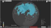
Da 2210Gino57 Gio Nov 19, 2015 5:15 pm
snow depth per la zona di Torino in Piemonte ... NW Italy
sui 15 cm ... 26.11.2015 ... 27.11.2015
2210Gino57- Messaggi : 5956
Data d'iscrizione : 29.10.15
Età : 66
Località : CH - 6044 LU 620 m s.l.m. Sicily 96010 Buccheri SR 820 m s.l.m. near M. Lauro Radar Sicily
Re: strong El Niño 2015 - 2016 and its impacts in Europe
Da 2210Gino57 Gio Nov 19, 2015 5:20 pm
incluso il contenuto seriamente per me lo potete chiudere ...
è inutile che io perdo tempo per darvi le News in anticipo

2210Gino57- Messaggi : 5956
Data d'iscrizione : 29.10.15
Età : 66
Località : CH - 6044 LU 620 m s.l.m. Sicily 96010 Buccheri SR 820 m s.l.m. near M. Lauro Radar Sicily
Contenuto sponsorizzato
Pagina 9 di 18 • 1 ... 6 ... 8, 9, 10 ... 13 ... 18
» December 2015: West Wind Weather central Europe Mediterranean
» February 2016: W Europe SSW PV split wavyr JS PFJ
» November 2016: Europe cold is coming PV split
» March 2016: Europe Meteo Spring PFJ and its impact or effect
|
|
|


» LMS in India: A learning management system
» Winter 2019: PV - Stratospheric Sudden Warming SSW Europe
» Nowcasting Gennaio 2018
» Scala Ef europea