
 Meteo4you
March 2016: Europe Meteo Spring PFJ and its impact or effect
Pagina 1 di 22 • 1, 2, 3 ... 11 ... 22 
March 2016: Europe Meteo Spring PFJ and its impact or effect
Da 2210Gino57 Mar Mar 01, 2016 1:45 am
per il riepilogo segui questo Link in poi
https://meteo4you.forumattivo.it/t85-modelli-live-primavera-2016#7995
e naturalmente il Thread precedente da me aperto
February 2016: W Europe SSW PV split wavyr JS PFJ
===
for more Infos ... follow ... coming soon
Titolo Thread
il Jet Stream alias PFJ ha una importanza per i suoi effetti
Ultima modifica di 2210Gino57 il Mar Mar 01, 2016 2:17 am - modificato 1 volta.

2210Gino57- Messaggi : 5956
Data d'iscrizione : 29.10.15
Età : 66
Località : CH - 6044 LU 620 m s.l.m. Sicily 96010 Buccheri SR 820 m s.l.m. near M. Lauro Radar Sicily
Re: March 2016: Europe Meteo Spring PFJ and its impact or effect
Da 2210Gino57 Mar Mar 01, 2016 2:05 am
and will remain near neutral most of the week
before trending negative over the weekend
after which the AO is predicted
to remain negative for the foreseeable future
-AO trend is reflective of the positive pressure gpt height anomalies
consolidating in the Arctic especially on the North Atlantic side
while pressure gpt height anomalies slowly fall
across the mid latitudes of the North Atlantic sector
including Western Europe and eventually Eastern United States
Polar Vortex ( PV ) is currently split over Northern Eurasia
and is predicted to split even further over the Eurasian continent
with the PV displaced so far South over the Eurasian continent
that is where the largest negative Temperature departures
are expected for the month of March 2016
with one lobe of the PV predicted to be over Siberia
that is where the most extreme cold Temperatures are expected
however a second lobe is predicted over Europe
that should bring relatively cold Weather to Europe as well
Ultima modifica di 2210Gino57 il Mar Mar 01, 2016 2:19 am - modificato 1 volta.
2210Gino57- Messaggi : 5956
Data d'iscrizione : 29.10.15
Età : 66
Località : CH - 6044 LU 620 m s.l.m. Sicily 96010 Buccheri SR 820 m s.l.m. near M. Lauro Radar Sicily
Re: March 2016: Europe Meteo Spring PFJ and its impact or effect
Da 2210Gino57 Mar Mar 01, 2016 2:15 am
almeno per tutta la 1ma decade di Marzo 2016

espansione Azores High ( Ridge )
caduta libera dei PFJ ( blocco )
discesa di Aria fredda polare ( Trough )
Aria mite inclusa ( frecce arancioni )
Ultima modifica di 2210Gino57 il Mar Mar 01, 2016 8:34 am - modificato 1 volta.
2210Gino57- Messaggi : 5956
Data d'iscrizione : 29.10.15
Età : 66
Località : CH - 6044 LU 620 m s.l.m. Sicily 96010 Buccheri SR 820 m s.l.m. near M. Lauro Radar Sicily
Re: March 2016: Europe Meteo Spring PFJ and its impact or effect
Da 2210Gino57 Mar Mar 01, 2016 8:30 am
svizzera centrale
da me dove abito io continua ad nevicare
===
Jet Stream ( PFJ ) sinking South
over Western central Europe
will bring colder than average Temperatures there
corrente a getto che affonda verso sud
Europa occidentale ed centrale portando freddo
2210Gino57- Messaggi : 5956
Data d'iscrizione : 29.10.15
Età : 66
Località : CH - 6044 LU 620 m s.l.m. Sicily 96010 Buccheri SR 820 m s.l.m. near M. Lauro Radar Sicily
Re: March 2016: Europe Meteo Spring PFJ and its impact or effect
Da 2210Gino57 Mar Mar 01, 2016 8:45 am
will bring cold Weather to West Europe
===
ed ecco la Traettoria e provenienza dei Lows
come sempre dal Labrador Sea NE USA Canada

Remember
occhio dal 03.03.2016 00z in poi
con un bel Low al centro N Italia
2210Gino57- Messaggi : 5956
Data d'iscrizione : 29.10.15
Età : 66
Località : CH - 6044 LU 620 m s.l.m. Sicily 96010 Buccheri SR 820 m s.l.m. near M. Lauro Radar Sicily
Re: March 2016: Europe Meteo Spring PFJ and its impact or effect
Da 2210Gino57 Mar Mar 01, 2016 9:10 am
regioni alpine ed nord italia
con Low al centro nord italia
la 535 gpt dam
2210Gino57- Messaggi : 5956
Data d'iscrizione : 29.10.15
Età : 66
Località : CH - 6044 LU 620 m s.l.m. Sicily 96010 Buccheri SR 820 m s.l.m. near M. Lauro Radar Sicily
Re: March 2016: Europe Meteo Spring PFJ and its impact or effect
Da 2210Gino57 Mer Mar 02, 2016 2:55 pm
in UK è in azione Low Jake alias Low Aloisia
il suo Fronte freddo è oggi 02.03.2016 over le nostre teste
inclusa vi è pure la linea di convergenza ( over germany )
ma Attenzione al prossimo Low in arrivo
sarebbe Low Bianca
il suo Fronte freddo arriva da noi per il weekend
cioè il nominato 06.03.2016 ( saccatura fredda )
sempre con lo stesso sistema
wavyr Jet Stream alias PFJ
Azores High expansion ( Ridge ) verso NE
Polar Low expansion ( Trough ) verso SW
2210Gino57- Messaggi : 5956
Data d'iscrizione : 29.10.15
Età : 66
Località : CH - 6044 LU 620 m s.l.m. Sicily 96010 Buccheri SR 820 m s.l.m. near M. Lauro Radar Sicily
Re: March 2016: Europe Meteo Spring PFJ and its impact or effect
Da 2210Gino57 Mer Mar 02, 2016 4:05 pm
dove abito io
fuori tira una strana aria
attualmente è un buio grigio
in lontananza si sentono rumore di Tuoni
sembra sia il Fronte freddo di Low Aloisia
Fronte freddo => triangolini blu
Storm Forecast
Valid: Wed 02 Mar 2016 06:00 h UTC to Thu 03 Mar 2016 06:00 h UTC
a deep cyclonic vortex will make its way from the atlantic towards central europe during the day
a sharp short wave Trough associated with it is forecast to move from ireland towards NW france
with 500 mb temperature below -35°C steep lapse rates despite the meager low level moisture
will ensure at least marginal latent instability
another Trough will be located directly over the balkans area with strong southerly flow
on its forward flank at mid to upper troposphere
DMC may develop especially over the eastern aegean sea
where more abundant moisture will be available
2210Gino57- Messaggi : 5956
Data d'iscrizione : 29.10.15
Età : 66
Località : CH - 6044 LU 620 m s.l.m. Sicily 96010 Buccheri SR 820 m s.l.m. near M. Lauro Radar Sicily
Re: March 2016: Europe Meteo Spring PFJ and its impact or effect
Da 2210Gino57 Mer Mar 02, 2016 8:20 pm
per questo weekend

è incredibile ...
dietro al Fronte freddo alla quota di 500 mb
la Temp scende a -30°C ed il bello è con Fulminazioni

2210Gino57- Messaggi : 5956
Data d'iscrizione : 29.10.15
Età : 66
Località : CH - 6044 LU 620 m s.l.m. Sicily 96010 Buccheri SR 820 m s.l.m. near M. Lauro Radar Sicily
Re: March 2016: Europe Meteo Spring PFJ and its impact or effect
Da 2210Gino57 Mer Mar 02, 2016 8:45 pm

NW Italy
Fulminazioni nei dintorni di Milano
2210Gino57- Messaggi : 5956
Data d'iscrizione : 29.10.15
Età : 66
Località : CH - 6044 LU 620 m s.l.m. Sicily 96010 Buccheri SR 820 m s.l.m. near M. Lauro Radar Sicily
Re: March 2016: Europe Meteo Spring PFJ and its impact or effect
Da 2210Gino57 Mer Mar 02, 2016 9:50 pm
2210Gino57- Messaggi : 5956
Data d'iscrizione : 29.10.15
Età : 66
Località : CH - 6044 LU 620 m s.l.m. Sicily 96010 Buccheri SR 820 m s.l.m. near M. Lauro Radar Sicily
Re: March 2016: Europe Meteo Spring PFJ and its impact or effect
Da 2210Gino57 Mer Mar 02, 2016 9:55 pm
dijon ginevra basilea ... poi segue normale fin su a francoforte
2210Gino57- Messaggi : 5956
Data d'iscrizione : 29.10.15
Età : 66
Località : CH - 6044 LU 620 m s.l.m. Sicily 96010 Buccheri SR 820 m s.l.m. near M. Lauro Radar Sicily
Re: March 2016: Europe Meteo Spring PFJ and its impact or effect
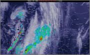
Da 2210Gino57 Mer Mar 02, 2016 10:25 pm
Low Aloisia
bel effetto del Fronte freddo di Low Aloisia
vedi Gulf of Lyon ( immagine Sat )
oppure FU Berlin DWD D
si è formato un Genoa Low ( 995 mb )

2210Gino57- Messaggi : 5956
Data d'iscrizione : 29.10.15
Età : 66
Località : CH - 6044 LU 620 m s.l.m. Sicily 96010 Buccheri SR 820 m s.l.m. near M. Lauro Radar Sicily
Re: March 2016: Europe Meteo Spring PFJ and its impact or effect
Da 2210Gino57 Mer Mar 02, 2016 11:10 pm
vedi USA ... Pacifico ... Bering Sea
bella la anomalia di tipo fredda
mentre nel NE USA anomalia di tipo calda
2210Gino57- Messaggi : 5956
Data d'iscrizione : 29.10.15
Età : 66
Località : CH - 6044 LU 620 m s.l.m. Sicily 96010 Buccheri SR 820 m s.l.m. near M. Lauro Radar Sicily
Re: March 2016: Europe Meteo Spring PFJ and its impact or effect
Da 2210Gino57 Gio Mar 03, 2016 12:15 am
svizzera centrale
bufera di vento e neve
il Genova Low si sposta in nottata verso la Toscana
https://meteo4you.forumattivo.it/t77p450-sotto-runnite-acuta-modelli-live-inverno-2016#7982


===
riepilogo
https://meteo4you.forumattivo.it/t86-march-2016-europe-meteo-spring-pfj-and-its-impact-or-effect#8009

nel cerchio blu piccolo i modelli prevedono ben 6 Lows
occhio al nuovo Low dal Nome Bianca
Ultima modifica di 2210Gino57 il Gio Mar 03, 2016 11:10 am - modificato 2 volte.
2210Gino57- Messaggi : 5956
Data d'iscrizione : 29.10.15
Età : 66
Località : CH - 6044 LU 620 m s.l.m. Sicily 96010 Buccheri SR 820 m s.l.m. near M. Lauro Radar Sicily
Re: March 2016: Europe Meteo Spring PFJ and its impact or effect
Da 2210Gino57 Gio Mar 03, 2016 12:45 am
Mediterraneo in ebollizione
Genova Low

2210Gino57- Messaggi : 5956
Data d'iscrizione : 29.10.15
Età : 66
Località : CH - 6044 LU 620 m s.l.m. Sicily 96010 Buccheri SR 820 m s.l.m. near M. Lauro Radar Sicily
Re: March 2016: Europe Meteo Spring PFJ and its impact or effect
Da 2210Gino57 Gio Mar 03, 2016 10:35 am
Europa
riguardo il weekend imminente
04.03.2016 - 07.03.2016
2210Gino57 ha scritto:non si tratta di una Perturbazione
trattasi di una Saccatura fredda da Nord
saccatura fredda => discesa fredda => Polar Trough
da alcuni Centri Meteo europei oltre Alpi
Meteo France
nouvelle descente air très froid en altitude demain 04.03.2016

come vi ho accennato
dopo Low Aloisia occhio al nuovo Low Bianca

https://meteo4you.forumattivo.it/t86-march-2016-europe-meteo-spring-pfj-and-its-impact-or-effect#8102
2210Gino57- Messaggi : 5956
Data d'iscrizione : 29.10.15
Età : 66
Località : CH - 6044 LU 620 m s.l.m. Sicily 96010 Buccheri SR 820 m s.l.m. near M. Lauro Radar Sicily
Re: March 2016: Europe Meteo Spring PFJ and its impact or effect
Da 2210Gino57 Gio Mar 03, 2016 11:45 am
Europa
Low Bianca
un misto di neve e pioggia
04.03.2016 - 07.03.2016
2210Gino57- Messaggi : 5956
Data d'iscrizione : 29.10.15
Età : 66
Località : CH - 6044 LU 620 m s.l.m. Sicily 96010 Buccheri SR 820 m s.l.m. near M. Lauro Radar Sicily
Re: March 2016: Europe Meteo Spring PFJ and its impact or effect
Da 2210Gino57 Gio Mar 03, 2016 7:50 pm
sembra che quello che vi ho anticipato
nel mio ultimo Thread precedente
ed in alcuni post nel Thread
aperto da Weather Regime si realizza
sperando di non aver rovinato il Thread
con i miei post ...
===
imminente weekend
04.03.2016 - 07.03.2016
Primavera in arrivo ? no il contrario
molti in Italia ( Forum Meteo ) pensano
che arrivi un semplice Peggioramento
ma invece è in arrivo il Polar Vortex alias Polar Trough
questo proprio over le nostre Lat. si divide ( split )
quindi Attenzione agli effetti nel Mediterraneo
an intense Polar Trough Vortex max has entered
the European long Wave Trough from the NW
it will split up over the Alps
with one Vortex max lifting into Scandinavia
the other digging into the Adriatic
Storm Forecast
Valid: Thu 03 Mar 2016 06:00 h UTC to Fri 04 Mar 2016 06:00 h UTC
Ultima modifica di 2210Gino57 il Gio Mar 03, 2016 8:50 pm - modificato 1 volta.
2210Gino57- Messaggi : 5956
Data d'iscrizione : 29.10.15
Età : 66
Località : CH - 6044 LU 620 m s.l.m. Sicily 96010 Buccheri SR 820 m s.l.m. near M. Lauro Radar Sicily
Re: March 2016: Europe Meteo Spring PFJ and its impact or effect
Da 2210Gino57 Gio Mar 03, 2016 8:15 pm
Polar Trough


2210Gino57- Messaggi : 5956
Data d'iscrizione : 29.10.15
Età : 66
Località : CH - 6044 LU 620 m s.l.m. Sicily 96010 Buccheri SR 820 m s.l.m. near M. Lauro Radar Sicily
Re: March 2016: Europe Meteo Spring PFJ and its impact or effect
Da 2210Gino57 Gio Mar 03, 2016 11:20 pm
Labrador Sea ... Polar Low

2210Gino57- Messaggi : 5956
Data d'iscrizione : 29.10.15
Età : 66
Località : CH - 6044 LU 620 m s.l.m. Sicily 96010 Buccheri SR 820 m s.l.m. near M. Lauro Radar Sicily
Re: March 2016: Europe Meteo Spring PFJ and its impact or effect
Da 2210Gino57 Ven Mar 04, 2016 4:25 pm
Ragazzi ... siete pronti ad accogliere
questa massa di Aria fredda polare ?
nella Meteo conosciuto come Polar Trough ?
ah no ... dimenticavo ...
per voi è una semplice Perturbazione di passaggio veloce
Ultima modifica di 2210Gino57 il Ven Mar 04, 2016 4:47 pm - modificato 1 volta.
2210Gino57- Messaggi : 5956
Data d'iscrizione : 29.10.15
Età : 66
Località : CH - 6044 LU 620 m s.l.m. Sicily 96010 Buccheri SR 820 m s.l.m. near M. Lauro Radar Sicily
Re: March 2016: Europe Meteo Spring PFJ and its impact or effect
Da 2210Gino57 Ven Mar 04, 2016 4:45 pm

2210Gino57- Messaggi : 5956
Data d'iscrizione : 29.10.15
Età : 66
Località : CH - 6044 LU 620 m s.l.m. Sicily 96010 Buccheri SR 820 m s.l.m. near M. Lauro Radar Sicily
Re: March 2016: Europe Meteo Spring PFJ and its impact or effect
Da WeatherRegime Ven Mar 04, 2016 6:09 pm
2210Gino57 ha scritto:buon pomeriggio
Ragazzi ... siete pronti ad accogliere
questa massa di Aria fredda polare ?
nella Meteo conosciuto come Polar Trough ?
ah no ... dimenticavo ...
per voi è una semplice Perturbazione di passaggio veloce
la perturbazione sarà veloce ma darà un un nuovo deciso colpetto ai pluviometri specie sui settori dell'alto piemonte, alta lombardia e ticino vedendo i wrf


WeatherRegime- Messaggi : 4401
Data d'iscrizione : 15.10.15
Età : 33
Località : cantù
Re: March 2016: Europe Meteo Spring PFJ and its impact or effect
Da 2210Gino57 Ven Mar 04, 2016 6:45 pm

e di questa situazione attuale
ne vedremo spesso a marzo 2016
è un vero e proprio replay
2210Gino57- Messaggi : 5956
Data d'iscrizione : 29.10.15
Età : 66
Località : CH - 6044 LU 620 m s.l.m. Sicily 96010 Buccheri SR 820 m s.l.m. near M. Lauro Radar Sicily
Contenuto sponsorizzato
Pagina 1 di 22 • 1, 2, 3 ... 11 ... 22
» February 2016: W Europe SSW PV split wavyr JS PFJ
» November 2016: Europe cold is coming PV split
» strong El Niño 2015 - 2016 and its impacts in Europe
» January 2016: Europe cold in development Winter is approaching
|
|
|


» LMS in India: A learning management system
» Winter 2019: PV - Stratospheric Sudden Warming SSW Europe
» Nowcasting Gennaio 2018
» Scala Ef europea