
 Meteo4you
December 2015: West Wind Weather central Europe Mediterranean
Pagina 2 di 27 •  1, 2, 3 ... 14 ... 27
Re: December 2015: West Wind Weather central Europe Mediterranean
Da 2210Gino57 Sab Nov 28, 2015 6:50 pm
Ultima modifica di 2210Gino57 il Dom Nov 29, 2015 7:50 pm - modificato 1 volta.

2210Gino57- Messaggi : 5956
Data d'iscrizione : 29.10.15
Età : 66
Località : CH - 6044 LU 620 m s.l.m. Sicily 96010 Buccheri SR 820 m s.l.m. near M. Lauro Radar Sicily
Re: December 2015: West Wind Weather central Europe Mediterranean
Da 2210Gino57 Sab Nov 28, 2015 8:10 pm
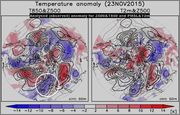
Zonal mean Temp change

https://meteo4you.forumattivo.it/t41p30-december-2015-west-wind-weather-central-europe-mediterranean#2348
2210Gino57- Messaggi : 5956
Data d'iscrizione : 29.10.15
Età : 66
Località : CH - 6044 LU 620 m s.l.m. Sicily 96010 Buccheri SR 820 m s.l.m. near M. Lauro Radar Sicily
Re: December 2015: West Wind Weather central Europe Mediterranean
Da 2210Gino57 Sab Nov 28, 2015 8:30 pm
da tenere sotto occhio il dopo 10.12.2015
adesso no so se si tratta della Wave1 oppure la Wave2
comunque è da monitorare
2210Gino57- Messaggi : 5956
Data d'iscrizione : 29.10.15
Età : 66
Località : CH - 6044 LU 620 m s.l.m. Sicily 96010 Buccheri SR 820 m s.l.m. near M. Lauro Radar Sicily
Re: December 2015: West Wind Weather central Europe Mediterranean
Da 2210Gino57 Sab Nov 28, 2015 9:35 pm

2210Gino57- Messaggi : 5956
Data d'iscrizione : 29.10.15
Età : 66
Località : CH - 6044 LU 620 m s.l.m. Sicily 96010 Buccheri SR 820 m s.l.m. near M. Lauro Radar Sicily
Re: December 2015: West Wind Weather central Europe Mediterranean
Da 2210Gino57 Dom Nov 29, 2015 10:45 am
vedi primo post a pagina 1

fu berlin dwd germany

2210Gino57- Messaggi : 5956
Data d'iscrizione : 29.10.15
Età : 66
Località : CH - 6044 LU 620 m s.l.m. Sicily 96010 Buccheri SR 820 m s.l.m. near M. Lauro Radar Sicily
Re: December 2015: West Wind Weather central Europe Mediterranean
Da 2210Gino57 Dom Nov 29, 2015 11:25 am
Valid: Sun 29 Nov 2015 06:00 h UTC to Mon 30 Nov 2015 06:00 h UTC
a large pressure depression down to 975 mb - 970 mb
covers norwegian sea iceland and northern north sea
it is encircled by the cyclonically curved
powerful jet stream with 300 mb
winds up to 75 m/s
a shortwave with a strong horizontal pressure gradient
and an active cold front is forecast by NWP models
to pass during the forecast period
from central UK Trough north sea netherlands
north germany south denmark up to NW poland
where it dissipates
most of the SE and S europe is covered
with the Azores High
that inhibits any convective activity
on the SE edge of the domain where
the SLP drops and an unstable Air mass occurs
isolated and scattered thunderstorms are possible
except SE part of the black sea E europe
remains under the cold and stable Air mass
vedi pure in archivio estofex
in poche parole Termini Meteo che io vi ho già accennato
2210Gino57- Messaggi : 5956
Data d'iscrizione : 29.10.15
Età : 66
Località : CH - 6044 LU 620 m s.l.m. Sicily 96010 Buccheri SR 820 m s.l.m. near M. Lauro Radar Sicily
Re: December 2015: West Wind Weather central Europe Mediterranean
Da 2210Gino57 Dom Nov 29, 2015 3:20 pm
850 0°C line ( white )
540 dm Thickness ( red )

West Weather situation ... Zyklonal ( Cyclonic ) WZ
zonal Flow ... Isentropic Mass Flux Potential ( CHI )

2210Gino57- Messaggi : 5956
Data d'iscrizione : 29.10.15
Età : 66
Località : CH - 6044 LU 620 m s.l.m. Sicily 96010 Buccheri SR 820 m s.l.m. near M. Lauro Radar Sicily
Re: December 2015: West Wind Weather central Europe Mediterranean
Da 2210Gino57 Dom Nov 29, 2015 6:50 pm
per modelli intendo il modello normale2210Gino57 ha scritto:avete visto i modelli per inizio dicembre 2015 ?
soprattutto la +336 h ed la +360 h
e non il modello anomalia
vedi pure
https://meteo4you.forumattivo.it/t41p45-december-2015-west-wind-weather-central-europe-mediterranean#2356
Ultima modifica di 2210Gino57 il Dom Nov 29, 2015 9:12 pm - modificato 1 volta.
2210Gino57- Messaggi : 5956
Data d'iscrizione : 29.10.15
Età : 66
Località : CH - 6044 LU 620 m s.l.m. Sicily 96010 Buccheri SR 820 m s.l.m. near M. Lauro Radar Sicily
Re: December 2015: West Wind Weather central Europe Mediterranean
Da 2210Gino57 Dom Nov 29, 2015 9:10 pm
il mio amico dalla slovenia afferma questo
dai modelli che lui stesso elabora
ecco le ultime sue News dal suo Blog ( Sito )
Forecasts in general agreement for a GW1 and TW1
being strongly present in the strat in mid-December 2015
No SSW yet ( uncertainty ) <> non si sa ancora per un SSW ( incertezza )
GW1 => Geopotential Wave1
TW1 => Temperature Wave1

quindi la mia intuizione era giusta
ho avuto un buon fiuto
infatti lo dicono i post nei miei Thread
easymeteo <> meteo4you
quindi non mi resta che restarci ( opinione )
per questa possibile SSW a dicembre 2015
e continuare ad monitorarla
ho riguardato i miei post ... vedi mio ultimo post
il grafico ( loop ) che ho postato sulla formazione SSW
infatti lo dico sempre
mi posso fidarmi dei modelli top che possiedo da anni
Ultima modifica di 2210Gino57 il Lun Nov 30, 2015 10:44 am - modificato 1 volta.
2210Gino57- Messaggi : 5956
Data d'iscrizione : 29.10.15
Età : 66
Località : CH - 6044 LU 620 m s.l.m. Sicily 96010 Buccheri SR 820 m s.l.m. near M. Lauro Radar Sicily
Re: December 2015: West Wind Weather central Europe Mediterranean
Da 2210Gino57 Dom Nov 29, 2015 11:20 pm
dicembre 2015 è alle porte
Super strong Godzilla El Niño prende rincorsa ( clou )
si espande sempre più ... come la NOAA aveva previsto
clou a dicembre 2015
===
grand Ensemble

===
ECMWF


2210Gino57- Messaggi : 5956
Data d'iscrizione : 29.10.15
Età : 66
Località : CH - 6044 LU 620 m s.l.m. Sicily 96010 Buccheri SR 820 m s.l.m. near M. Lauro Radar Sicily
Re: December 2015: West Wind Weather central Europe Mediterranean
Da 2210Gino57 Dom Nov 29, 2015 11:50 pm

2210Gino57- Messaggi : 5956
Data d'iscrizione : 29.10.15
Età : 66
Località : CH - 6044 LU 620 m s.l.m. Sicily 96010 Buccheri SR 820 m s.l.m. near M. Lauro Radar Sicily
Re: December 2015: West Wind Weather central Europe Mediterranean
Da 2210Gino57 Lun Nov 30, 2015 2:00 am
central europe
da tenere sotto occhio la metà di dicembre 2015
Strato ... NH ... Wave1 ... Wave2 ... Polar Vortex

2210Gino57- Messaggi : 5956
Data d'iscrizione : 29.10.15
Età : 66
Località : CH - 6044 LU 620 m s.l.m. Sicily 96010 Buccheri SR 820 m s.l.m. near M. Lauro Radar Sicily
Re: December 2015: West Wind Weather central Europe Mediterranean
Da 2210Gino57 Lun Nov 30, 2015 3:00 am
Storm Forecast
Valid: Mon 30 Nov 2015 06:00 h UTC to Tue 01 Dec 2015 06:00 h UTC
low pressure systems are found over scandinavia
and over the eastern mediterranean sea
a new low along a frontal wave lies initially
over the british isles and moves quickly
over benelux and germany
together with high pressure over
the western and central mediterranean the scandinavian lows
produce a tight pressure gradient across much of western
central and northern europe ( 45° N - 65° N )
with strong westerly winds
unstable maritime arctic airmasses produce wintry showers
with occasional thunder over the norwegian sea
and the baltic sea
instability is decreasing along the occluded cold front
entering belarus and ukraine in the morning
still some severe convective wind event remains possible
Polar Vortex collapses
but i wonder if it is also behind the fact that the peak
temperature occurs all the way up at 10 mb
as air within the stratosphere is compressed ahead of the wave ?
the use of the phrase further compressive warming seems to imply this
i see the descending motion which i thought might relate
to cooling of the wave is more a result
of the heat maximum at 10 mb in some way
causing the zonal flow to decelerate above it
( as flow lines diverge around it ? )
with convergence forcing subsidence
the residual circulation is
in the vertical ? that bit is less clear
i have noticed from the 3D animations
that having weakened the vortex
the warmest air tends to end up focused
as a distinct anticyclonic circulation
to accompany the displaced or split vortex
seemingly behaving like a tropospheric high pressure cell
i suppose these tend to correlate well with the areas
of blocking high pressure following SSW events
in poche parole Termini Meteo
che io ho già accennato e descritto
incluso i vari modelli ... grafici revised ... etc.
2210Gino57- Messaggi : 5956
Data d'iscrizione : 29.10.15
Età : 66
Località : CH - 6044 LU 620 m s.l.m. Sicily 96010 Buccheri SR 820 m s.l.m. near M. Lauro Radar Sicily
Re: December 2015: West Wind Weather central Europe Mediterranean
Da 2210Gino57 Lun Nov 30, 2015 11:45 am
siamo in piena Frontal zone
Edit ... 30.11.2015 12:25:30 h MEZ


2210Gino57 ha scritto:la massa di aria fredda marittimma polare
spinge ad alta quota la massa di aria calda
vedi la configurazione barica ed posizione delle H ed L
oppure semplicemente il sat ... ancora meglio il loop WV


2210Gino57- Messaggi : 5956
Data d'iscrizione : 29.10.15
Età : 66
Località : CH - 6044 LU 620 m s.l.m. Sicily 96010 Buccheri SR 820 m s.l.m. near M. Lauro Radar Sicily
Re: December 2015: West Wind Weather central Europe Mediterranean
Da riccardo 94 Lun Nov 30, 2015 1:21 pm

riccardo 94- Messaggi : 1895
Data d'iscrizione : 30.10.15
Età : 29
Località : Alpignano(TO)
Re: December 2015: West Wind Weather central Europe Mediterranean
Da 2210Gino57 Lun Nov 30, 2015 1:26 pm
Snowfall in Florina ... Greece ... 28.11.2015
2210Gino57- Messaggi : 5956
Data d'iscrizione : 29.10.15
Età : 66
Località : CH - 6044 LU 620 m s.l.m. Sicily 96010 Buccheri SR 820 m s.l.m. near M. Lauro Radar Sicily
Re: December 2015: West Wind Weather central Europe Mediterranean
Da 2210Gino57 Lun Nov 30, 2015 1:55 pm
non so se voi lo state notando ...
incredibile la situazione attuale
cioè la configurazione barica
incluso la posizione delle Highs e dei Lows
la mega Azores High con il suo espandersi
ha sfornato una H secondaria con Nome Xena
stesso tempo H Xena
viene sepolta dal Fronte dei Lows in arrivo
dal Labrador Sea ma soprattutto dal Frontal zone
che ha per Nome Philipp ( vedi fu berlin dwd D )
praticamente il Fronte di Philipp manda ad alta quota la H
cioè la massa di Aria calda ... da notare pure il fortissimo Jet
ovvero il PFJ alias Polar Front Jetstream
Low Philipp ... Frontal zone ( massa di Aria fredda marittima polare )
https://meteo4you.forumattivo.it/t41p45-december-2015-west-wind-weather-central-europe-mediterranean#2390
Ultima modifica di 2210Gino57 il Mer Gen 06, 2016 6:24 am - modificato 1 volta.
2210Gino57- Messaggi : 5956
Data d'iscrizione : 29.10.15
Età : 66
Località : CH - 6044 LU 620 m s.l.m. Sicily 96010 Buccheri SR 820 m s.l.m. near M. Lauro Radar Sicily
Re: December 2015: West Wind Weather central Europe Mediterranean
Da WeatherRegime Lun Nov 30, 2015 2:01 pm
2210Gino57 ha scritto:buonasera
il mio amico dalla slovenia afferma questo
dai modelli che lui stesso elabora
ecco le ultime sue News dal suo Blog ( Sito )
Forecasts in general agreement for a GW1 and TW1
being strongly present in the strat in mid-December 2015
No SSW yet ( uncertainty ) <> non si sa ancora per un SSW ( incertezza )
GW1 => Geopotential Wave1
TW1 => Temperature Wave1
quindi la mia intuizione era giusta
ho avuto un buon fiuto
infatti lo dicono i post nei miei Thread
easymeteo <> meteo4you
quindi non mi resta che restarci ( opinione )
per questa possibile SSW a dicembre 2015
e continuare ad monitorarla
ho riguardato i miei post ... vedi mio ultimo post
il grafico ( loop ) che ho postato sulla formazione SSW
infatti lo dico sempre... anche se molti modelli software $$$
mi posso fidarmi dei modelli top che possiedo da anni
come mai parli di un tuo fiuto o intuizione quando il SSW lo hai postato qui da fonti di alti lidi esteri?
in questo momento abbiamo sicuramente un quadro TLC che ci rema contro, QBO-SF-ENSO+ modulando di conseguenza AO e NAO su valori + e ne stiamo gia visualizzando gli effetti da fine ottobre.
però rimango molto, molto aperto da quelle forzanti che ci sono state fornite in questo ultimo periodo, il SAI, un'onda Atlantica e Siberiani High particolarmente attivi e quel WR venuto ad impostarsi nel periodo ottobrino.
rimango dell'idea quindi come gia detto in altro post che qualcosa non mi fa essere propenso ad un continuo su questo trend novembrino con AO e NAO +
aggiornamento NAM Martineau


WeatherRegime- Messaggi : 4401
Data d'iscrizione : 15.10.15
Età : 33
Località : cantù
Re: December 2015: West Wind Weather central Europe Mediterranean
Da 2210Gino57 Lun Nov 30, 2015 4:40 pm
per Alessandro ( Ale90 )
riguardo il tuo attuale Articolo in HP ( 30.11.2015 )
conferme sul rallentamento della circolazione profonda in Atlantico
lo hai visto letto notato su easymeteo ?
tra il 08.10.2015 ed il 15.10.2015
Thread dal Titolo
3a decade Ottobre: 22.10.2015 cold Air mss from NE Trough
vi ho accennato qualcosa riguardo la Atlantic cold blob SSTA
cioè nominata pure nella Meteo come Global Oceanic Conveyor Belt
conveyor belt system
2210Gino57- Messaggi : 5956
Data d'iscrizione : 29.10.15
Età : 66
Località : CH - 6044 LU 620 m s.l.m. Sicily 96010 Buccheri SR 820 m s.l.m. near M. Lauro Radar Sicily
Re: December 2015: West Wind Weather central Europe Mediterranean
Da 2210Gino57 Mar Dic 01, 2015 3:35 am
Geostrophic Flux ... Geostrophic Flow ... Geostrophic Jet Streak
https://meteo4you.forumattivo.it/t41p60-december-2015-west-wind-weather-central-europe-mediterranean#2400
AO is currently positive and is predicted to remain positive
extrapolation of predicted hemispheric trends suggests a cooling trend
for both Northern Europe and the Eastern United States
for the second half of December 2015
as the Wave configuration becomes more favorable
for high latitude blocking
500 mb geopotential heights ( dam contours ) and geopotential height anomalies ( m shading )
on 30 November 2015 at 00Z
note the Low heights over the North Atlantic side of the Arctic
and with High heights over W Europe W Siberia and W North America
in addition based on some recent research low Arctic sea ice
especially in the Barent Kara Seas favors a negative Winter AO
However in the near term low geopotential heights
are predicted for the Barents Kara Seas region
if this persists into January 2016 this could be an indication
that our expectation for transition
to a more negative AO regime is in jeopardy
===
Estofex
Storm Forecast
Valid: Tue 01 Dec 2015 06:00 h UTC to Wed 02 Dec 2015 06:00 h UTC
a long wave Trough amplifies into easternmost europe
while a long wave Ridge builds from iberia towards the N Sea
this configuration temporarily forces the still strong mid level Flow
to turn into a NWesterly direction over most of the Continent
at the surface, a deepening Low moves Eastward across the ukraine
and a mature Storm Cyclone is located near iceland
they are connected by a long and well established Frontal boundary
which pushes Southward as a cold Front in the wake
of the ukrainian Low while it reverses into a warm Front
across central europe and the british isles
buona giornata
2210Gino57- Messaggi : 5956
Data d'iscrizione : 29.10.15
Età : 66
Località : CH - 6044 LU 620 m s.l.m. Sicily 96010 Buccheri SR 820 m s.l.m. near M. Lauro Radar Sicily
Re: December 2015: West Wind Weather central Europe Mediterranean
Da 2210Gino57 Mar Dic 01, 2015 3:05 pm
apertura di questo Thread incluso Titolo appropriato ... 27.11.2015
naturalmnte incluso pure il contenuto
ed eccolo ... 01.12.2015
dopo avervelo accennato io
non è fantastico ?
bellissima la configurazione barica

di cosa si tratta cosa è e tutto il resto vedi post in questo Thread
potrebbe infine formarsi un bellissimo
come è che viene nominato nella meteo ?
Shapiro Keyser Cyclone model
dalla posizione e latitudine
viene pure nominato
Norwegian Cyclone model
ve ne ho accennato spesso
vedi su easymeteo
2210Gino57- Messaggi : 5956
Data d'iscrizione : 29.10.15
Età : 66
Località : CH - 6044 LU 620 m s.l.m. Sicily 96010 Buccheri SR 820 m s.l.m. near M. Lauro Radar Sicily
Re: December 2015: West Wind Weather central Europe Mediterranean
Da ale90 Mar Dic 01, 2015 3:34 pm

ale90- Admin
- Messaggi : 2324
Data d'iscrizione : 13.10.15
Età : 33
Località : Caravaggio -

Re: December 2015: West Wind Weather central Europe Mediterranean
Da 2210Gino57 Mar Dic 01, 2015 4:15 pm
vi avevo accennato in questo Thread giorni fa
e se ben ricordo pure qualcosina su easymeteo
prima del cambio quì su meteo4you
riguardo la metà di dicembre 2015 ... ricordate ?
quindi nessun motivo di un copia e incolla
oppure simile d altri lidi meteo centri meteo etc.
loro ed i suoi news arrivano quasi sempre
dopo avervelo accennato io ... incluso estofex
è tutta mia Esperienza Meteo raccolta negli anni
comunque sia ...

wave1 ... wave2
2210Gino57- Messaggi : 5956
Data d'iscrizione : 29.10.15
Età : 66
Località : CH - 6044 LU 620 m s.l.m. Sicily 96010 Buccheri SR 820 m s.l.m. near M. Lauro Radar Sicily
Re: December 2015: West Wind Weather central Europe Mediterranean
Da 2210Gino57 Mar Dic 01, 2015 4:35 pm
Shapiro Keyser Cyclone model
dalla posizione e latitudine
Norwegian Cyclone model
===
Geostrophic Wind ... Geostrophic Jet Streak
https://meteo4you.forumattivo.it/t41p60-december-2015-west-wind-weather-central-europe-mediterranean#2470


per coloro che non sanno cosa sia un geostrophic wind
insomma situazione ed configurazione barica attuale


2210Gino57- Messaggi : 5956
Data d'iscrizione : 29.10.15
Età : 66
Località : CH - 6044 LU 620 m s.l.m. Sicily 96010 Buccheri SR 820 m s.l.m. near M. Lauro Radar Sicily
Re: December 2015: West Wind Weather central Europe Mediterranean
Da 2210Gino57 Mar Dic 01, 2015 6:15 pm
La bufera di neve negli USA del 1888
per le immagini sarà difficile ma hai pure dei modelli ?
voglio intendere modelli di epoca ma più in dettaglio
nelle immagini postate non vi è nessun dettaglio ...
USA ... NE US ... Blizzard ... 11.03.1888 - 14.03.1888
Type: ExtraTropical Caclone ... Blizzard ... Winter Storm
Formed: March 11 ... 1888
Dissipated: March 14 ... 1888
Lowest Pressure: 980 mb ... 29.0 inHg
Maximum: 58 inches ... 145 cm
Damage: 25 milion $ ( 1888 ) => 660 milion $ ( 2015 )
Areas affected: Eastern US ... Eastern Canada
2210Gino57- Messaggi : 5956
Data d'iscrizione : 29.10.15
Età : 66
Località : CH - 6044 LU 620 m s.l.m. Sicily 96010 Buccheri SR 820 m s.l.m. near M. Lauro Radar Sicily
Contenuto sponsorizzato
Pagina 2 di 27 • 1, 2, 3 ... 14 ... 27
» start of March 2017: Atlantic W Europe Stormy Weather
» January 2017: West Europe started cold vs frost
» West Europe Alpine regions: July 2016 see previous Thread
» November 2016: Europe cold is coming PV split
|
|
|


» LMS in India: A learning management system
» Winter 2019: PV - Stratospheric Sudden Warming SSW Europe
» Nowcasting Gennaio 2018
» Scala Ef europea