
 Meteo4you
December 2015: West Wind Weather central Europe Mediterranean
Pagina 7 di 27 •  1 ... 6, 7, 8 ... 17 ... 27
Re: December 2015: West Wind Weather central Europe Mediterranean
Da 2210Gino57 Sab Dic 05, 2015 7:00 pm
Ragazzi ... chi di voi conosce oppure sentito nominare
del famoso Modello by NOAA CFSv2 ?
mi sono arrivati i nuovi Modelli del NH a quota 10 mb ( Strato )
CFS Weekly ( fino a +4 weeks )
CFS Monthly ( January 2016 - September 2016 ) + Archivio
Archivio a partire dal novembre 205 18z
interessati ?

2210Gino57- Messaggi : 5956
Data d'iscrizione : 29.10.15
Età : 66
Località : CH - 6044 LU 620 m s.l.m. Sicily 96010 Buccheri SR 820 m s.l.m. near M. Lauro Radar Sicily
Re: December 2015: West Wind Weather central Europe Mediterranean
Da riccardo 94 Sab Dic 05, 2015 7:03 pm
2210Gino57 ha scritto:News
Ragazzi ... chi di voi conosce oppure sentito nominare
del famoso Modello by NOAA CFSv2 ?
mi sono arrivati i nuovi Modelli del NH a quota 10 mb ( Strato )
CFS Weekly ( fino a +4 weeks )
CFS Monthly ( January 2016 - September 2016 ) + Archivio
Archivio a partire dal novembre 205 18z
interessati ?
tipo questo?
perchè la versione è disponibile in modo gratuito su meteociel


riccardo 94- Messaggi : 1895
Data d'iscrizione : 30.10.15
Età : 29
Località : Alpignano(TO)
Re: December 2015: West Wind Weather central Europe Mediterranean
Da 2210Gino57 Sab Dic 05, 2015 7:10 pm
https://meteo4you.forumattivo.it/t41p165-december-2015-west-wind-weather-central-europe-mediterranean#2918
scusatemi ... piccola modifica
non si trattano di modelli semplici usuali
trattasi del NH ... Strato ... Polar Vortex ( PV )
per il momento la quota è 10 mb
forse ne verranno aggiunte altre in futuro
Strato => Stratosphere
NH => Northern Hemisphere
PV => Polar Vortex
da non confondere con il PV alias Potential Vorticity
CFSv2 by NOAA ... 10 mb Temp Hight ... 7 day averages
2210Gino57- Messaggi : 5956
Data d'iscrizione : 29.10.15
Età : 66
Località : CH - 6044 LU 620 m s.l.m. Sicily 96010 Buccheri SR 820 m s.l.m. near M. Lauro Radar Sicily
Re: December 2015: West Wind Weather central Europe Mediterranean
Da 2210Gino57 Sab Dic 05, 2015 7:40 pm
https://meteo4you.forumattivo.it/t41p150-december-2015-west-wind-weather-central-europe-mediterranean#2917
lo sai e lo sapete che non ne ho bisogno
anzi ... anche questo lo ripeto volentieri ( se volete )
se qualcuno di voi utenti ha delle domande da farmi
sono pronto a rispondere su tutto ... almeno ci provo
Ultima modifica di 2210Gino57 il Ven Dic 18, 2015 7:34 pm - modificato 1 volta.
2210Gino57- Messaggi : 5956
Data d'iscrizione : 29.10.15
Età : 66
Località : CH - 6044 LU 620 m s.l.m. Sicily 96010 Buccheri SR 820 m s.l.m. near M. Lauro Radar Sicily
Re: December 2015: West Wind Weather central Europe Mediterranean
Da 2210Gino57 Sab Dic 05, 2015 7:40 pm

2210Gino57- Messaggi : 5956
Data d'iscrizione : 29.10.15
Età : 66
Località : CH - 6044 LU 620 m s.l.m. Sicily 96010 Buccheri SR 820 m s.l.m. near M. Lauro Radar Sicily
Re: December 2015: West Wind Weather central Europe Mediterranean
Da 2210Gino57 Sab Dic 05, 2015 7:50 pm
===
NH ... Strato ... PV ... 10 mb
central Europe
Natale 2015 insieme al PV ?
+384 h ... 21.12.2015 12z
2210Gino57- Messaggi : 5956
Data d'iscrizione : 29.10.15
Età : 66
Località : CH - 6044 LU 620 m s.l.m. Sicily 96010 Buccheri SR 820 m s.l.m. near M. Lauro Radar Sicily
Re: December 2015: West Wind Weather central Europe Mediterranean
Da 2210Gino57 Sab Dic 05, 2015 8:05 pm
dove abito io ... Nebbia
2210Gino57- Messaggi : 5956
Data d'iscrizione : 29.10.15
Età : 66
Località : CH - 6044 LU 620 m s.l.m. Sicily 96010 Buccheri SR 820 m s.l.m. near M. Lauro Radar Sicily
Re: December 2015: West Wind Weather central Europe Mediterranean
Da 2210Gino57 Sab Dic 05, 2015 9:35 pm
Toc Toc ... ci siete ?
===
se ci siete avete notato il Sat ? ... Mediterraneo
2210Gino57- Messaggi : 5956
Data d'iscrizione : 29.10.15
Età : 66
Località : CH - 6044 LU 620 m s.l.m. Sicily 96010 Buccheri SR 820 m s.l.m. near M. Lauro Radar Sicily
Re: December 2015: West Wind Weather central Europe Mediterranean
Da 2210Gino57 Sab Dic 05, 2015 9:55 pm
situazione attuale strongest El Niñno 2015

===
ve lo ricordate questo modello ?
penso ve lo abbia postato su easymeteo

2210Gino57- Messaggi : 5956
Data d'iscrizione : 29.10.15
Età : 66
Località : CH - 6044 LU 620 m s.l.m. Sicily 96010 Buccheri SR 820 m s.l.m. near M. Lauro Radar Sicily
Re: December 2015: West Wind Weather central Europe Mediterranean
Da 2210Gino57 Sab Dic 05, 2015 11:50 pm
Flooding Watch ... Flooding Warning
secondo FU Berlin DWD D => Low Ted
secondo FU Berlin DWD D => Low Shigeru
secondo MetOffice UK => Low Desmond
in UK => WinterStorm Desmond
la più colpita è Cumbria UK
2210Gino57- Messaggi : 5956
Data d'iscrizione : 29.10.15
Età : 66
Località : CH - 6044 LU 620 m s.l.m. Sicily 96010 Buccheri SR 820 m s.l.m. near M. Lauro Radar Sicily
Re: December 2015: West Wind Weather central Europe Mediterranean
Da 2210Gino57 Dom Dic 06, 2015 1:00 am
UK Winter Forecast 2015 - 2016
central Europe
riassumize
i must also add that this winter 2015
has been very difficult to predict
given the unique situation
of the very strong El Niño
and QBO combination
at the moment the Polar Vortex is rather strong
and is helping and maintaining the zonal Flow
we are currently enduring
i did expect this to occur however if you recall
in our autumn forecast
i suggested that november would be a stormy
and a largely unsettled month
one would assume that a strong Vortex
would be very hard to breakdown
as was the case in the Winter of 2013 - 2014
however there are strong indications
that the vortex will be gradually
weakened through december by a combination
of the Siberian Ridge and the Tropical influence
brought about by El Niño 2015 - 2016
that said and as a result of the strong Vortex
a mild unsettled and perhaps stormy outlook
is more probable during the first period
of december and possibly beyond however
i wouldn rule out a weakening
of the Atlantic Flow from mid month
as the Heights across the Arctic
become more negative
a negative Arctic Oscillation is looking
very likely throughout this Winter
and although this wont be a certainty
for cold conditions over the UK
it should mean the Atlantic will become
less active but only if the Vortex
remains away from north america canada
this type of set up that we have seen
across the pond over the past two Winters
is not forecast to repeat this year
and as such i believe this will aid
in a weaker Atlantic Flow ... eventually
with this in mind colder incursions are not
ruled out in the last third of december
although the emphasis on december as a whole
will be mild and mixed
most long range models coupled
with my historical research both agree on an mixed
and mild Flow for december so any colder
periods should be taken at face value rather than
a sign for a longer period of cold Weather
now throughout december i will be monitoring
the Polar Vortex for developments which will give us
a clue for the rest of Winter
so expect further updates on this situation
here is the typical pattern expected in december
now as a result of so much uncertainty beyond december
confidence in the rest of this forecast will be low
as mentioned earlier i firmly believe
that we will see a Sudden Stratospheric Warming
which will weaken or even breakdown the Vortex
when this warming may occur is very much uncertain
but current thoughts are for an early january breakdown
that being said the QBO may delay this occurrence
and the stratosphere will be monitored through december
for development
for now i am happy to keep with the early warming
thoughts which is likely to bring colder conditions
for the second half of january and much of february

vedi pure i modelli postati in precedenza
2210Gino57- Messaggi : 5956
Data d'iscrizione : 29.10.15
Età : 66
Località : CH - 6044 LU 620 m s.l.m. Sicily 96010 Buccheri SR 820 m s.l.m. near M. Lauro Radar Sicily
Re: December 2015: West Wind Weather central Europe Mediterranean
Da 2210Gino57 Dom Dic 06, 2015 9:10 am
https://meteo4you.forumattivo.it/t41p165-december-2015-west-wind-weather-central-europe-mediterranean#2935

strong wind ... strong gust ... Jet Streak ... PFJ

2210Gino57- Messaggi : 5956
Data d'iscrizione : 29.10.15
Età : 66
Località : CH - 6044 LU 620 m s.l.m. Sicily 96010 Buccheri SR 820 m s.l.m. near M. Lauro Radar Sicily
Re: December 2015: West Wind Weather central Europe Mediterranean
Da 2210Gino57 Dom Dic 06, 2015 9:50 am
come accennato è in arrivo Low Uwe
il suo Fronte arriva fin giù in Florida US
la H Yvonne viene quindi spostata verso i balcani
dal Sat si nota benissimo il cambio ... ondulazione
con il avanzare di Low Uwe ( meridional Flow )
Low Ted ed Low Shigeru sono ancora ben attivi ed visibili
2210Gino57- Messaggi : 5956
Data d'iscrizione : 29.10.15
Età : 66
Località : CH - 6044 LU 620 m s.l.m. Sicily 96010 Buccheri SR 820 m s.l.m. near M. Lauro Radar Sicily
Re: December 2015: West Wind Weather central Europe Mediterranean
Da 2210Gino57 Dom Dic 06, 2015 11:20 am


by NOAA

ECMWF


ECMWF by NOAA
2210Gino57- Messaggi : 5956
Data d'iscrizione : 29.10.15
Età : 66
Località : CH - 6044 LU 620 m s.l.m. Sicily 96010 Buccheri SR 820 m s.l.m. near M. Lauro Radar Sicily
Re: December 2015: West Wind Weather central Europe Mediterranean
Da 2210Gino57 Dom Dic 06, 2015 12:30 pm
England floods ... Cumbria

Jet Stream
the Jet Stream ( Jet Streak )
is currently SW NE oriented
over the british isles ... UK
coupled with the Jet is a Frontal zone
which in the last 24 hours or less stationary
over the W of england and scotland was over.
small Waves which originated in the Front
the already serious rainfall from time to time
give an extra boost
the mountainous landscape did the rest
because it is not surprising in these circumstances
that it is precisely at the W side
of the higher elevations of the extra rain is abundant
===
12 h sometimes the evening was taken out
of the rain gauge was nearby keswick
to arrive at 100 millimeters
at that time occurred several rivers
already beyond its shores
thereafter there was in the course of the evening
and at night even 50 mm to 60 mm in case of
a single place had to deal with more
than 200 millimeters in 36 h
===
vedi pure estofex ... evtl. archivio
Storm Forecast
Valid: Sun 06 Dec 2015 06:00 h UTC to Mon 07 Dec 2015 06:00 h UTC
2210Gino57- Messaggi : 5956
Data d'iscrizione : 29.10.15
Età : 66
Località : CH - 6044 LU 620 m s.l.m. Sicily 96010 Buccheri SR 820 m s.l.m. near M. Lauro Radar Sicily
Re: December 2015: West Wind Weather central Europe Mediterranean
Da 2210Gino57 Dom Dic 06, 2015 2:05 pm
nella tarda serata di oggi 06.12.2015
se ho tempo vi posto la 2a parte
riassuntiva ( riassumize )
oppure conosciuta come synopsis
sulla situazione attuale ... cioè
USA ( NE ) ... Atlantic ... Europe
vedi pure i modelli postati
Atlantic zonal Flow strikes
Winter outlook and raid into Polar Vortex
2210Gino57- Messaggi : 5956
Data d'iscrizione : 29.10.15
Età : 66
Località : CH - 6044 LU 620 m s.l.m. Sicily 96010 Buccheri SR 820 m s.l.m. near M. Lauro Radar Sicily
Re: December 2015: West Wind Weather central Europe Mediterranean
Da 2210Gino57 Dom Dic 06, 2015 2:35 pm
la Tempesta da Uragano
( in Europa di preciso Tempesta autunnale )
dal Nome Desmond ( in Germania Low Ted )
ha provocato danni seri ed alluvioni torrenziali
Cairngorm Mountains ( Scozia ) a quota 1245 m
forte raffiche di Vento ( 210 km/h )
per la Pioggia vedi nel post precedente

2210Gino57- Messaggi : 5956
Data d'iscrizione : 29.10.15
Età : 66
Località : CH - 6044 LU 620 m s.l.m. Sicily 96010 Buccheri SR 820 m s.l.m. near M. Lauro Radar Sicily
Re: December 2015: West Wind Weather central Europe Mediterranean
Da 2210Gino57 Dom Dic 06, 2015 3:00 pm
pure nel mediterraneo vi è vorticità dinamicità
una specie di Vortice ...
2210Gino57- Messaggi : 5956
Data d'iscrizione : 29.10.15
Età : 66
Località : CH - 6044 LU 620 m s.l.m. Sicily 96010 Buccheri SR 820 m s.l.m. near M. Lauro Radar Sicily
Re: December 2015: West Wind Weather central Europe Mediterranean
Da 2210Gino57 Dom Dic 06, 2015 3:45 pm
Zonal wind ( U )
Zonal wind ( U ) vs. pressure
( in High Resolution )

NH
Zonal wind ( U )
Zonal wind ( U ) vs. latitude
Stratosphere U vs. Latitude 1 mb

NH
Zonal wind ( U )
Zonal wind ( U ) vs. latitude
Stratosphere U vs. Latitude 10 mb

come vi aveo accennato tempo fa su easymeteo
per altri parametri ... sono disponibili
2210Gino57- Messaggi : 5956
Data d'iscrizione : 29.10.15
Età : 66
Località : CH - 6044 LU 620 m s.l.m. Sicily 96010 Buccheri SR 820 m s.l.m. near M. Lauro Radar Sicily
Re: December 2015: West Wind Weather central Europe Mediterranean
Da 2210Gino57 Dom Dic 06, 2015 4:25 pm
Temp Geopot Height

CFSv2 ... weekly
week 1 ... week 4
10 mb ... Temp Hight
7 day averages

2210Gino57- Messaggi : 5956
Data d'iscrizione : 29.10.15
Età : 66
Località : CH - 6044 LU 620 m s.l.m. Sicily 96010 Buccheri SR 820 m s.l.m. near M. Lauro Radar Sicily
Re: December 2015: West Wind Weather central Europe Mediterranean
Da 2210Gino57 Dom Dic 06, 2015 7:00 pm
riguardo il tuo Articolo in HP sui Hurricanes in Atlantico
Anno da record per i cicloni tropicali
ti sei scordato il più importante
Atllantic Hrcne Basin
pochi Uragani si ma molti dei quali
sono riusciti ad arrivare fino in UK ed oltre
questi praticamente oltre ad essere ex Uragani
sono stati nominati Major per avere superato la Cat.3
oltre ad El Niño vi è pure altro motivo
del perchè in questa Hrcne Season 2015
pochi Hrcnes in Atlantico ... => SAL
NOAA NWS NHC
below normal Atlantic Hurricane Season 2015 ends
from June to November
active Eastern and central Pacific Hrcne Season shatter records
http://www.noaanews.noaa.gov/stories2015/120115-below-normal-atlantic-hurricane-season-ends-active-eastern-and-central-pacific-seasons-shatter-records.html
Off Topic
2210Gino57- Messaggi : 5956
Data d'iscrizione : 29.10.15
Età : 66
Località : CH - 6044 LU 620 m s.l.m. Sicily 96010 Buccheri SR 820 m s.l.m. near M. Lauro Radar Sicily
Re: December 2015: West Wind Weather central Europe Mediterranean
Da 2210Gino57 Dom Dic 06, 2015 9:25 pm
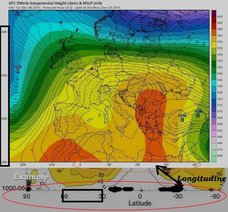
ma ci siete ?
se ci siete qualcuno di voi riesce a darsi una spinta sforzo
e darmi per favore una risposta ? ...
ve ne intendete di gradi ? latitudine longitudine etc. ?
sapete dirmi quale zona è intesa quella che vedete nel modello

cerchio rosso
Grazie !
2210Gino57- Messaggi : 5956
Data d'iscrizione : 29.10.15
Età : 66
Località : CH - 6044 LU 620 m s.l.m. Sicily 96010 Buccheri SR 820 m s.l.m. near M. Lauro Radar Sicily
Re: December 2015: West Wind Weather central Europe Mediterranean
Da ale90 Dom Dic 06, 2015 10:36 pm
2210Gino57 ha scritto:buonasera
ma ci siete ?
se ci siete qualcuno di voi riesce a darsi una spinta sforzo
e darmi per favore una risposta ? ...
ve ne intendete di gradi ? latitudine longitudine etc. ?
sapete dirmi quale zona è intesa quella che vedete nel modello
cerchio rosso
Grazie !
latitudini 30-60 è quella sulle verticali

ale90- Admin
- Messaggi : 2324
Data d'iscrizione : 13.10.15
Età : 33
Località : Caravaggio -

Re: December 2015: West Wind Weather central Europe Mediterranean
Da 2210Gino57 Dom Dic 06, 2015 11:00 pm
Grazie Alessandro
abbi pazienza ... le Scuole superiori Professionale etc.
le ho finite nel lontano 1976
quindi tutto quello che si legge a sinistra dello 0° è Lat.
mentre tutto quello che si legge a destra dello 0° è Long.
no perchè mi confondo nei modelli ad esempio
che riguardano lo zonal wind etc. ... cioè Strato PV
quindi se io vorrei sapere lo zonal wind alle nostre Latitudini
quali devo scegliere ? ... vedi Esempio

2210Gino57- Messaggi : 5956
Data d'iscrizione : 29.10.15
Età : 66
Località : CH - 6044 LU 620 m s.l.m. Sicily 96010 Buccheri SR 820 m s.l.m. near M. Lauro Radar Sicily
Re: December 2015: West Wind Weather central Europe Mediterranean
Da ale90 Dom Dic 06, 2015 11:16 pm
per le nostre latitudini è 30N-50N o anche 40N-60N (che però traglia fuori il sud Italia)
ale90- Admin
- Messaggi : 2324
Data d'iscrizione : 13.10.15
Età : 33
Località : Caravaggio -
Contenuto sponsorizzato
Pagina 7 di 27 • 1 ... 6, 7, 8 ... 17 ... 27
» start of March 2017: Atlantic W Europe Stormy Weather
» January 2017: West Europe started cold vs frost
» West Europe Alpine regions: July 2016 see previous Thread
» November 2016: Europe cold is coming PV split
|
|
|


» LMS in India: A learning management system
» Winter 2019: PV - Stratospheric Sudden Warming SSW Europe
» Nowcasting Gennaio 2018
» Scala Ef europea