
 Meteo4you
SW Europe: June 2017 Bay of Biscay WAA DWA CWA 01
Pagina 8 di 9 •  1, 2, 3, 4, 5, 6, 7, 8, 9
Re: SW Europe: June 2017 Bay of Biscay WAA DWA CWA 01
Da 2210Gino57 Mer Lug 05, 2017 10:05 am
ci risiamo ...
ed eccolo ( Low Uwe )
yo yo Weather
oppure detto anche
roller coaster Weather
vedi i post precedenti
mitteleuropa
here we go again
the show goes on
nostre Latitudini
regioni Alpine ed confini
Alps region and neighboring countries
arriva Low Uwe ( upper level Low )
di nuovo stesso punto
Bay of Biscay
di nuovo stessa situazione
unseasonably Trough

per la precisa Traettoria dove colpirà etc.
è ancora presto per i dettagli ...
Ultima modifica di 2210Gino57 il Mer Lug 05, 2017 1:59 pm - modificato 3 volte.

2210Gino57- Messaggi : 5956
Data d'iscrizione : 29.10.15
Età : 66
Località : CH - 6044 LU 620 m s.l.m. Sicily 96010 Buccheri SR 820 m s.l.m. near M. Lauro Radar Sicily
Re: SW Europe: June 2017 Bay of Biscay WAA DWA CWA 01
Da 2210Gino57 Mer Lug 05, 2017 11:25 am
con i Grafici rielaborati da me ed Modelli
ecco la situazione Isobarica

da notare Low Uwe
infine si unisce ad Low Till
da monitorare il Low senza Nome
nel NW tra Portogallo ed Spagna
per il 06.07.2017
vedi in questo Modello
già spesse volte postato


da notare nel Atlantic Hrcne Basin
possibile Tropical Cyclone developing
2210Gino57- Messaggi : 5956
Data d'iscrizione : 29.10.15
Età : 66
Località : CH - 6044 LU 620 m s.l.m. Sicily 96010 Buccheri SR 820 m s.l.m. near M. Lauro Radar Sicily
Re: SW Europe: June 2017 Bay of Biscay WAA DWA CWA 01
Da 2210Gino57 Mer Lug 05, 2017 12:00 pm

2210Gino57- Messaggi : 5956
Data d'iscrizione : 29.10.15
Età : 66
Località : CH - 6044 LU 620 m s.l.m. Sicily 96010 Buccheri SR 820 m s.l.m. near M. Lauro Radar Sicily
Re: SW Europe: June 2017 Bay of Biscay WAA DWA CWA 01
Da WeatherRegime Mer Lug 05, 2017 12:03 pm


WeatherRegime- Messaggi : 4401
Data d'iscrizione : 15.10.15
Età : 33
Località : cantù
Re: SW Europe: June 2017 Bay of Biscay WAA DWA CWA 01
Da 2210Gino57 Mer Lug 05, 2017 12:15 pm
https://meteo4you.forumattivo.it/t168p175-sw-europe-bay-of-biscay-waa-dwa-cwa#19904
Example

2210Gino57- Messaggi : 5956
Data d'iscrizione : 29.10.15
Età : 66
Località : CH - 6044 LU 620 m s.l.m. Sicily 96010 Buccheri SR 820 m s.l.m. near M. Lauro Radar Sicily
Re: SW Europe: June 2017 Bay of Biscay WAA DWA CWA 01
Da 2210Gino57 Mer Lug 05, 2017 12:40 pm
unseasonably Trough
ecco il motivo
ve ne ho accennato spesso in questo Thread
il Jet Stream ( 200 mb )
il JS è spezzato
quindi per i Through da Nord
facile entrare alle nostre Latitudini

Jet Stream is identified as Winds at 300 mb ( during Winter )
Jet Stream is identified as Winds at 200 mb ( during Summer )
nel Modello con la X lo si nota bene

2210Gino57- Messaggi : 5956
Data d'iscrizione : 29.10.15
Età : 66
Località : CH - 6044 LU 620 m s.l.m. Sicily 96010 Buccheri SR 820 m s.l.m. near M. Lauro Radar Sicily
Re: SW Europe: June 2017 Bay of Biscay WAA DWA CWA 01
Da 2210Gino57 Mer Lug 05, 2017 1:10 pm
questi Modelli nominati pure Teleconnection
non hanno ( da non fraintendere ) nssuna influenza
alla situazione attuale che abbiamo alle nostre Latitudini
quindi facile da comprendere
per essere Luglio ovvero Estate ... unseasonably
cioè unseasonably > insolito
non dico che non hanno a che vedere
ma non hanno nessuna influenza
affinchè il Jet Stream non riprenda
la sua posizione rotta direzione regolare
al momento il JS è spezzato
ecco il perchè ho scritto ( da non fraintendere )
vi ho pure postato alcuni grafici rielaborati
in uno dei post precedenti
adesso non vado ad cercarli ...
2210Gino57- Messaggi : 5956
Data d'iscrizione : 29.10.15
Età : 66
Località : CH - 6044 LU 620 m s.l.m. Sicily 96010 Buccheri SR 820 m s.l.m. near M. Lauro Radar Sicily
Re: SW Europe: June 2017 Bay of Biscay WAA DWA CWA 01
Da 2210Gino57 Mer Lug 05, 2017 2:05 pm
ci risiamo ...
ed eccolo ( Low Uwe )
yo yo Weather
oppure detto anche
roller coaster Weather
mitteleuropa
here we go again
the show goes on
nostre Latitudini
regioni Alpine ed confini
Alps region and neighboring countries
arriva Low Uwe ( upper level Low )
di nuovo stesso punto
Bay of Biscay
di nuovo stessa situazione
unseasonably Trough
https://meteo4you.forumattivo.it/t168p175-sw-europe-bay-of-biscay-waa-dwa-cwa#19902
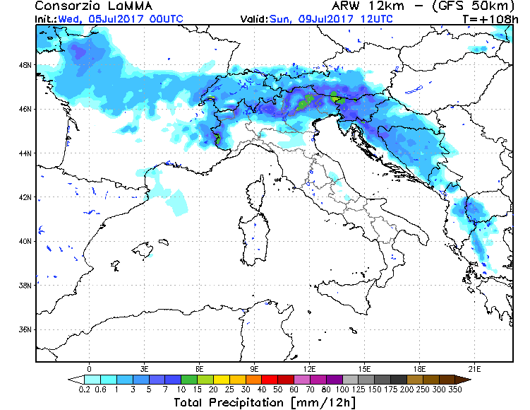
la situazione si fa interessante
tra Giovedì 06.07.2017 ed Venerdì 07.07.2017
soprattutto Venerdì 07.07.2017
sempre come al solito ... nel pomeriggio sera
i Valori necessari per svilupparsi Celle Temporalesche ci sono
specialmente il LI ed il CAPE ... poi vi è pure il CIN
vedremo ( per i dettagli )
===
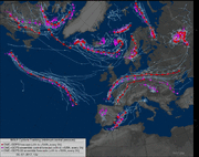
osservando il Sat si nota
come nel NW Africa Stretto di Gibilterra ed Bay of Biscay
qualcosa si muove ... inteso sono le Nubi ( Clouds )
naturalmente è inteso pure il Trough ( upper level Low )
come pure il formarsi del Trough da cui si forma Low Uwe
Il Trough è una Saccatura ad alta quota
questo fa si che avviene un calo di Pressione
ed quindi si viene ad formare altro Low indipendente ad bassa quota
vedi FU B DWD D
2210Gino57- Messaggi : 5956
Data d'iscrizione : 29.10.15
Età : 66
Località : CH - 6044 LU 620 m s.l.m. Sicily 96010 Buccheri SR 820 m s.l.m. near M. Lauro Radar Sicily
Re: SW Europe: June 2017 Bay of Biscay WAA DWA CWA 01
Da WeatherRegime Mer Lug 05, 2017 2:20 pm
WeatherRegime- Messaggi : 4401
Data d'iscrizione : 15.10.15
Età : 33
Località : cantù
Re: SW Europe: June 2017 Bay of Biscay WAA DWA CWA 01
Da 2210Gino57 Mer Lug 05, 2017 3:00 pm
la Temperatura alle nostre Latitudini
fa come il yo yo ... sale ed scende
insomma come pure il roller coaster
in poche parole si aggira sui +30°C
il tutto ( come già spesso ripetuto )
la situazione barica si ripete
Low nel Bay of Biscay ... Jet Stream
ed il unseasonably Trough ( Aria fredda )
questo vuol dire ...
L > Low > rotazione in enso antiorario
quindi arrivo di Aria caldo umida subTropicale da SW
ciò significa per le nostre Latitudini ... contrasto
siamo ( come già detto ) in una specie di Sandwich
2210Gino57- Messaggi : 5956
Data d'iscrizione : 29.10.15
Età : 66
Località : CH - 6044 LU 620 m s.l.m. Sicily 96010 Buccheri SR 820 m s.l.m. near M. Lauro Radar Sicily
Re: SW Europe: June 2017 Bay of Biscay WAA DWA CWA 01
Da 2210Gino57 Mer Lug 05, 2017 5:30 pm
here we go again
the show goes on
nostre Latitudini
regioni Alpine ed confini
Alps region and neighboring countries
dapprima mi sono detto ( chiesto )
ma Estofex ?
ed invece no ... Estofex non si è sbagliato
https://meteo4you.forumattivo.it/t168p150-sw-europe-bay-of-biscay-waa-dwa-cwa#19896
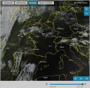
dal Sat attuale si notano primi accenni

2210Gino57- Messaggi : 5956
Data d'iscrizione : 29.10.15
Età : 66
Località : CH - 6044 LU 620 m s.l.m. Sicily 96010 Buccheri SR 820 m s.l.m. near M. Lauro Radar Sicily
Re: SW Europe: June 2017 Bay of Biscay WAA DWA CWA 01
Da 2210Gino57 Mer Lug 05, 2017 5:40 pm
al momento domina la H ( Gisela ed Francoise )
https://meteo4you.forumattivo.it/t168p175-sw-europe-bay-of-biscay-waa-dwa-cwa#19912
ma quello che arriva dopo è da monitorare ...
cioè weekend imminente
Low Uwe ed il suo Low secondario
sempre come già vi ho descritto ... da SW
2210Gino57- Messaggi : 5956
Data d'iscrizione : 29.10.15
Età : 66
Località : CH - 6044 LU 620 m s.l.m. Sicily 96010 Buccheri SR 820 m s.l.m. near M. Lauro Radar Sicily
Re: SW Europe: June 2017 Bay of Biscay WAA DWA CWA 01
Da 2210Gino57 Mer Lug 05, 2017 8:40 pm
here we go again
the show goes on
nostre Latitudini
regioni Alpine ed confini
Alps region and neighboring countries
come già detto in uno dei post precedenti
abbiamo una specie di
yo yo Weather ( roller coaster )
guardate questo loop
2 m Temp in °C

scuro sui +35°C
chiaro sui +25C
2210Gino57- Messaggi : 5956
Data d'iscrizione : 29.10.15
Età : 66
Località : CH - 6044 LU 620 m s.l.m. Sicily 96010 Buccheri SR 820 m s.l.m. near M. Lauro Radar Sicily
Re: SW Europe: June 2017 Bay of Biscay WAA DWA CWA 01
Da 2210Gino57 Mer Lug 05, 2017 8:45 pm
here we go again
the show goes on
nostre Latitudini
regioni Alpine ed confini
Alps region and neighboring countries
come già detto in uno dei post precedenti
abbiamo una specie di
yo yo Weather ( roller coaster )
il BeNeLux la vede per bene questo weekend
2210Gino57- Messaggi : 5956
Data d'iscrizione : 29.10.15
Età : 66
Località : CH - 6044 LU 620 m s.l.m. Sicily 96010 Buccheri SR 820 m s.l.m. near M. Lauro Radar Sicily
Re: SW Europe: June 2017 Bay of Biscay WAA DWA CWA 01
Da 2210Gino57 Mer Lug 05, 2017 9:20 pm
here we go again
the show goes on
nostre Latitudini
regioni Alpine ed confini
Alps region and neighboring countries
https://meteo4you.forumattivo.it/t168p175-sw-europe-bay-of-biscay-waa-dwa-cwa#19915
guardate il GFS NCEP ed ECMWF
Jet Stream ... CAPE

guardate il Jet Stream

si nota bene come il JS è irregolare
2210Gino57- Messaggi : 5956
Data d'iscrizione : 29.10.15
Età : 66
Località : CH - 6044 LU 620 m s.l.m. Sicily 96010 Buccheri SR 820 m s.l.m. near M. Lauro Radar Sicily
Re: SW Europe: June 2017 Bay of Biscay WAA DWA CWA 01
Da 2210Gino57 Mer Lug 05, 2017 9:45 pm
here we go again
the show goes on
nostre Latitudini
regioni Alpine ed confini
Alps region and neighboring countries
guardate il Sat

Ultima modifica di 2210Gino57 il Mer Lug 05, 2017 10:48 pm - modificato 1 volta.
2210Gino57- Messaggi : 5956
Data d'iscrizione : 29.10.15
Età : 66
Località : CH - 6044 LU 620 m s.l.m. Sicily 96010 Buccheri SR 820 m s.l.m. near M. Lauro Radar Sicily
Re: SW Europe: June 2017 Bay of Biscay WAA DWA CWA 01
Da 2210Gino57 Mer Lug 05, 2017 10:30 pm
Giugno 2017
globalmente al secondo posto
più caldo sin dal 1979
+0.38°C più caldo
( medio-lungo Termine Giugno 1981 - 2010 )

2210Gino57- Messaggi : 5956
Data d'iscrizione : 29.10.15
Età : 66
Località : CH - 6044 LU 620 m s.l.m. Sicily 96010 Buccheri SR 820 m s.l.m. near M. Lauro Radar Sicily
Re: SW Europe: June 2017 Bay of Biscay WAA DWA CWA 01
Da 2210Gino57 Mer Lug 05, 2017 11:30 pm
situazione Sandwich
loop
2210Gino57- Messaggi : 5956
Data d'iscrizione : 29.10.15
Età : 66
Località : CH - 6044 LU 620 m s.l.m. Sicily 96010 Buccheri SR 820 m s.l.m. near M. Lauro Radar Sicily
Re: SW Europe: June 2017 Bay of Biscay WAA DWA CWA 01
Da 2210Gino57 Gio Lug 06, 2017 2:55 am
here we go again
the show goes on
nostre Latitudini
regioni Alpine ed confini
Alps region and neighboring countries
Low Uwe
yo yo Weather
oppure detto anche
roller coaster Weather
come già vi ho accennato ...
GFS ... Jet Stream

torm Forecast
Valid: Thu 06.07.2017 06:00 UTC to Fri 07.07.2017 06:00 UTC
Low Geopotential across Northern Europe
yields a Westerly mid-level Flow
over the central parts of Europe
embedded short-wave Troughs
travel Eastwards during the period
over Southern Europe intense Cut-off Low ( Uwe )
is situated over Portugal and slowly moves East
it will be a focus of convective Storms on Thursday
downstream African High Ridges
into Western and central Europe
associated with an elevated mixed layer
spreading across Western Europe
along the Northern edge of the EML
Cyclogenesis is expected as
a short-wave Trough overspreads
the warm Front late in the period
Southern Alps ... Eastern Alps
in a moderate North-Westerly mid-level Flow
right entrance of a mid-level Jet affects
the area in the afternoon
in a moist and unstable Air mass
with rather high CAPE and weak CIN
Storms are expected to form over the Mountains
during the day
main potential for severe Storms
exists along the dryline dividing
well-mixed Air over the Alps and moist Southerly Flow
advected upslope
locally favourable veering low-level Winds
may support supercells that travel slowly
posing a threat of large Hail and excessive Precipitation
severe Wind gusts are not ruled out
weaker vertical Wind shear further West limits
the potential over Northern Italy
however some isolated severe Storms
are not ruled out as well
il resto della synopsis come sempre su Estofex ( in inglese )
praticamente quello che già ho descritto io nei post precedenti


loop
2210Gino57- Messaggi : 5956
Data d'iscrizione : 29.10.15
Età : 66
Località : CH - 6044 LU 620 m s.l.m. Sicily 96010 Buccheri SR 820 m s.l.m. near M. Lauro Radar Sicily
Re: SW Europe: June 2017 Bay of Biscay WAA DWA CWA 01
Da WeatherRegime Gio Lug 06, 2017 10:46 am
2210Gino57 ha scritto:piccolo Off Topic
Giugno 2017
globalmente al secondo posto
più caldo sin dal 1979
+0.38°C più caldo
( medio-lungo Termine Giugno 1981 - 2010 )
Grazie Gino dell'informazione. Ma c'è il dato preciso consultabile?
WeatherRegime- Messaggi : 4401
Data d'iscrizione : 15.10.15
Età : 33
Località : cantù
Re: SW Europe: June 2017 Bay of Biscay WAA DWA CWA 01
Da 2210Gino57 Gio Lug 06, 2017 12:00 pm
Ultima modifica di 2210Gino57 il Gio Lug 06, 2017 3:44 pm - modificato 1 volta.
2210Gino57- Messaggi : 5956
Data d'iscrizione : 29.10.15
Età : 66
Località : CH - 6044 LU 620 m s.l.m. Sicily 96010 Buccheri SR 820 m s.l.m. near M. Lauro Radar Sicily
Re: SW Europe: June 2017 Bay of Biscay WAA DWA CWA 01
Da 2210Gino57 Gio Lug 06, 2017 12:30 pm
da settimane abbiamo spesso
questo Tipo di Configurazione barica
https://meteo4you.forumattivo.it/t168p175-sw-europe-bay-of-biscay-waa-dwa-cwa#19922
Bay of Biscay
Low Uwe
cioè un upper Trough Vortex
with associated Surface Low
in poche parole
come già vi ho descritto
abbiamo una massa di Aria instabile
( anche alle quote alte )
appunto
un Vortice ( Uwe ) ad alta quota
con assiciato un Minimo ( L )
a quota bassa ( Superfice )
https://postimg.org/image/y56piqoax
vedi pure FU Berlin DWD D

tornando alla massa di Aria instabile
Low Uwe ed il Trough fanno si
che questa massa di Aria instabile
ovvero caldo umida da SW
sale pure ad alta quota
ciò vuol dire ...
si vengono ad formare
Supercell Temporalesche
ma non solo ...
la velocità del Vento aumenta
ed nello stesso tempo
vi è pure un cambio del Vento
quindi difficile fare una Previsione
dove colpirano i Temporali
vedi Estofex

2210Gino57- Messaggi : 5956
Data d'iscrizione : 29.10.15
Età : 66
Località : CH - 6044 LU 620 m s.l.m. Sicily 96010 Buccheri SR 820 m s.l.m. near M. Lauro Radar Sicily
Re: SW Europe: June 2017 Bay of Biscay WAA DWA CWA 01
Da 2210Gino57 Gio Lug 06, 2017 12:35 pm
here we go again
the show goes on
nostre Latitudini
regioni Alpine ed confini
Alps region and neighboring countries
ecco il evolvere della situazione prossimi giorni
con incertezza ...

2210Gino57- Messaggi : 5956
Data d'iscrizione : 29.10.15
Età : 66
Località : CH - 6044 LU 620 m s.l.m. Sicily 96010 Buccheri SR 820 m s.l.m. near M. Lauro Radar Sicily
Re: SW Europe: June 2017 Bay of Biscay WAA DWA CWA 01
Da 2210Gino57 Gio Lug 06, 2017 9:45 pm
here we go again
the show goes on
nostre Latitudini
regioni Alpine ed confini
Alps region and neighboring countries
https://meteo4you.forumattivo.it/t168p175-sw-europe-bay-of-biscay-waa-dwa-cwa#19926

vedi su Estofex
synopsis interessante
a zonal Flow regime persists ... as the frontal zone extends
from Ireland over Germany to the Ukraine
pain and extreme SE-Bay of Biscay/SW-France ...
a difficult task to pinpoint CI for the far West Mediterranean
including the Balearic Islands
upper pattern shows a diffluent and also divergent Flow regime
only increasing during the forecast with a consolidating
upper Jet core along the South fringe of that Vortex ( over South Spain )

2210Gino57- Messaggi : 5956
Data d'iscrizione : 29.10.15
Età : 66
Località : CH - 6044 LU 620 m s.l.m. Sicily 96010 Buccheri SR 820 m s.l.m. near M. Lauro Radar Sicily
Re: SW Europe: June 2017 Bay of Biscay WAA DWA CWA 01
Da 2210Gino57 Ven Lug 07, 2017 5:20 pm
https://meteo4you.forumattivo.it/t168p175-sw-europe-bay-of-biscay-waa-dwa-cwa#19927
lo Spettacolo ha inizio ...
vedi il Sat ( Fulminazione ... Radar )
2210Gino57- Messaggi : 5956
Data d'iscrizione : 29.10.15
Età : 66
Località : CH - 6044 LU 620 m s.l.m. Sicily 96010 Buccheri SR 820 m s.l.m. near M. Lauro Radar Sicily
Contenuto sponsorizzato
Pagina 8 di 9 • 1, 2, 3, 4, 5, 6, 7, 8, 9
» cntrl Europe Alps NW Italy: June 2016 see previous Thread
» January 2017: West Europe started cold vs frost
» start of March 2017: Atlantic W Europe Stormy Weather
» Special: Atlantic Train of Lows Bay of Biscay Cyclogenesis
|
|
|


» LMS in India: A learning management system
» Winter 2019: PV - Stratospheric Sudden Warming SSW Europe
» Nowcasting Gennaio 2018
» Scala Ef europea