
 Meteo4you
SW Europe: June 2017 Bay of Biscay WAA DWA CWA 01
Pagina 6 di 9 •  1, 2, 3, 4, 5, 6, 7, 8, 9
Re: SW Europe: June 2017 Bay of Biscay WAA DWA CWA 01
Da 2210Gino57 Mer Giu 28, 2017 2:35 pm


2210Gino57- Messaggi : 5956
Data d'iscrizione : 29.10.15
Età : 66
Località : CH - 6044 LU 620 m s.l.m. Sicily 96010 Buccheri SR 820 m s.l.m. near M. Lauro Radar Sicily
Re: SW Europe: June 2017 Bay of Biscay WAA DWA CWA 01
Da 2210Gino57 Mer Giu 28, 2017 3:00 pm
here we go again
the show goes on
nostre Latitudini
regioni Alpine ed confini
Alps region and neighboring countries
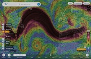
Low Rasmund

da notare le 2 Supercell ( in rosso )
la loro direzione ...
si dirigono verso il Ticino
ma dapprima il NW Italy
cioè ... Lombardia ... Prov. di Como
occhio ... la Supercell aumenta ...

2210Gino57- Messaggi : 5956
Data d'iscrizione : 29.10.15
Età : 66
Località : CH - 6044 LU 620 m s.l.m. Sicily 96010 Buccheri SR 820 m s.l.m. near M. Lauro Radar Sicily
Re: SW Europe: June 2017 Bay of Biscay WAA DWA CWA 01
Da 2210Gino57 Mer Giu 28, 2017 3:10 pm
NW Africa ... Stretto di Gibilterra
Temp a quota 850 mb ( +28°C )

===
riecco il Radar
incluso la direzione delle Supercell

mentre da noi alle nostre Latitudini
persiste il Maltempo ed altro
nel Mediterraneo del Sud brucia
Temp a quota 850 mb ( +30°C )
2210Gino57- Messaggi : 5956
Data d'iscrizione : 29.10.15
Età : 66
Località : CH - 6044 LU 620 m s.l.m. Sicily 96010 Buccheri SR 820 m s.l.m. near M. Lauro Radar Sicily
Re: SW Europe: June 2017 Bay of Biscay WAA DWA CWA 01
Da 2210Gino57 Mer Giu 28, 2017 4:15 pm
here we go again
the show goes on
nostre Latitudini
regioni Alpine ed confini
Alps region and neighboring countries
Low Rasmund
per il NW Italy la situazione attuale è questa
come vi ho sempre accennato ( incluso grafici )
ecco come è la situazione attuale nel NW Italy
effetto veramente dinamibo da Supercell
il Jet Stream ( 300 mb ) => Jet streak
ha in questo caso una priorità assoluta
effetto WAA DWA CWA PVA NVA
divergence ... convergence
Isotachs ... Isobars
Jet Stream > Jet streak > left exit
in poche parole
Cyclogenesis in connection with the left exit
and the right entrance region of a Jet streak
Trough > L > Low > left entrance > left exit
Ridge > H > High > right entrance > right exit
L > Low > rotazione i senso antiorario
Cyclonic flow > counterclockwise
H > High > rotazione i senso orario
Anticyclonic flow > Clockwise
Low Pressure
as rises it spins counter clockwise
as a result cloudy stormy weather forms
High Pressure
as air sinks it spins clockwise
as a result sunny clear weather forms

2210Gino57- Messaggi : 5956
Data d'iscrizione : 29.10.15
Età : 66
Località : CH - 6044 LU 620 m s.l.m. Sicily 96010 Buccheri SR 820 m s.l.m. near M. Lauro Radar Sicily
Re: SW Europe: June 2017 Bay of Biscay WAA DWA CWA 01
Da 2210Gino57 Mer Giu 28, 2017 4:45 pm
here we go again
the show goes on
nostre Latitudini
regioni Alpine ed confini
Alps region and neighboring countries
Low Rasmund
la situazione si fa critica
Aria fredda dal NW ( Trough )
si scontra con Aria caldo umida dal SW ( Ridge )
inoltre vi è pure il Foehn ... sempre il Jet Stream
attualmente dove abito io
il cielo si oscura ... Tuoni
2210Gino57- Messaggi : 5956
Data d'iscrizione : 29.10.15
Età : 66
Località : CH - 6044 LU 620 m s.l.m. Sicily 96010 Buccheri SR 820 m s.l.m. near M. Lauro Radar Sicily
Re: SW Europe: June 2017 Bay of Biscay WAA DWA CWA 01
Da 2210Gino57 Mer Giu 28, 2017 5:00 pm
here we go again
the show goes on
nostre Latitudini
regioni Alpine ed confini
Alps region and neighboring countries
https://meteo4you.forumattivo.it/t168p125-sw-europe-bay-of-biscay-waa-dwa-cwa#19845
Low Rasmund

Low Rasmund si va ad posizionarsi nel mittel europa
vedi FU B DWD D ed apre il rubinetto ...
Pioggia ed Temporali ...


2210Gino57- Messaggi : 5956
Data d'iscrizione : 29.10.15
Età : 66
Località : CH - 6044 LU 620 m s.l.m. Sicily 96010 Buccheri SR 820 m s.l.m. near M. Lauro Radar Sicily
Re: SW Europe: June 2017 Bay of Biscay WAA DWA CWA 01
Da 2210Gino57 Mer Giu 28, 2017 6:55 pm
molto vivace ... molti Utenti ...
ma si ...
===
mitteleuropa
here we go again
the show goes on
nostre Latitudini
regioni Alpine ed confini
Alps region and neighboring countries
Low Rasmund

sulla sinistra ... Jet Stream ( 300 mb )
sulla destra ... MSLP ( 500 mb )
colore scuro > Lows
colore chiaro > Highs
Isola di Elba
bella la V Shape ( mega )

2210Gino57- Messaggi : 5956
Data d'iscrizione : 29.10.15
Età : 66
Località : CH - 6044 LU 620 m s.l.m. Sicily 96010 Buccheri SR 820 m s.l.m. near M. Lauro Radar Sicily
Re: SW Europe: June 2017 Bay of Biscay WAA DWA CWA 01
Da 2210Gino57 Mer Giu 28, 2017 7:10 pm
here we go again
the show goes on
https://meteo4you.forumattivo.it/t168p125-sw-europe-bay-of-biscay-waa-dwa-cwa#19847
nostre Latitudini
regioni Alpine ed confini
Alps region and neighboring countries
Low Rasmund
da come è posizionato il JS ( 300 mb )
sembra che per i prossimi giorni
non cambia nulla ...
il JS attualmente dal NE USA ( Labrador Sea )
è molto forte ... very strong Jet streak
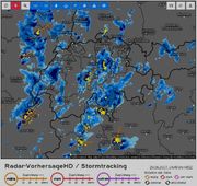
dal Radar si nota la massa di Nubi ( Pioggia )
con integrati Celle Temporalesche ... ( Cbs )
2210Gino57- Messaggi : 5956
Data d'iscrizione : 29.10.15
Età : 66
Località : CH - 6044 LU 620 m s.l.m. Sicily 96010 Buccheri SR 820 m s.l.m. near M. Lauro Radar Sicily
Re: SW Europe: June 2017 Bay of Biscay WAA DWA CWA 01
Da 2210Gino57 Mer Giu 28, 2017 7:40 pm
here we go again
the show goes on
nostre Latitudini
regioni Alpine ed confini
Alps region and neighboring countries
Low Rasmund
come già accennato
la enormità di Low Rasmund

2210Gino57- Messaggi : 5956
Data d'iscrizione : 29.10.15
Età : 66
Località : CH - 6044 LU 620 m s.l.m. Sicily 96010 Buccheri SR 820 m s.l.m. near M. Lauro Radar Sicily
Re: SW Europe: June 2017 Bay of Biscay WAA DWA CWA 01
Da 2210Gino57 Mer Giu 28, 2017 8:45 pm
nostre Latitudini
regioni Alpine ed confini
Alps region and neighboring countries
Halleluja ... Allegria ...
i Modelli vedono per la prossima settimana
a partire dal 03.07.2017 bel Tempo
Summer comeback
ma Attenzione !
per il 05.07.2017 potrebbe iniziare
il tutto da capo ... vedi Bay of Biscay

per i dettagli è ancora presto ...

2210Gino57- Messaggi : 5956
Data d'iscrizione : 29.10.15
Età : 66
Località : CH - 6044 LU 620 m s.l.m. Sicily 96010 Buccheri SR 820 m s.l.m. near M. Lauro Radar Sicily
Re: SW Europe: June 2017 Bay of Biscay WAA DWA CWA 01
Da 2210Gino57 Mer Giu 28, 2017 9:05 pm
here we go again
the show goes on
nostre Latitudini
regioni Alpine ed confini
Alps region and neighboring countries
Low Rasmund
Attenzione !!!
NW Italy ... Lombardia
Provincia di Como
Flash Flood Alert
Pericolo Alluvione
dal 28.06.2017 fino al 29.06.2017


vedi pure Estofex
Level 2

Ultima modifica di 2210Gino57 il Mer Giu 28, 2017 9:34 pm - modificato 2 volte.
2210Gino57- Messaggi : 5956
Data d'iscrizione : 29.10.15
Età : 66
Località : CH - 6044 LU 620 m s.l.m. Sicily 96010 Buccheri SR 820 m s.l.m. near M. Lauro Radar Sicily
Re: SW Europe: June 2017 Bay of Biscay WAA DWA CWA 01
Da 2210Gino57 Mer Giu 28, 2017 9:30 pm
here we go again
the show goes on
https://meteo4you.forumattivo.it/t168p125-sw-europe-bay-of-biscay-waa-dwa-cwa#19851
nostre Latitudini
regioni Alpine ed confini
Alps region and neighboring countries
Low Rasmund
Attenzione !!!
NW Italy ... Lombardia
Provincia di Como
Flash Flood Alert
Pericolo Alluvione
dal 28.06.2017 fino al 29.06.2017
dal Sat sembra che si venga ad formare un Minimo

dalla synopsis su Estofex
come pure il FU B DWD D
vedono un Genoa Low
occhio al Wind shear

2210Gino57- Messaggi : 5956
Data d'iscrizione : 29.10.15
Età : 66
Località : CH - 6044 LU 620 m s.l.m. Sicily 96010 Buccheri SR 820 m s.l.m. near M. Lauro Radar Sicily
Re: SW Europe: June 2017 Bay of Biscay WAA DWA CWA 01
Da 2210Gino57 Mer Giu 28, 2017 10:50 pm
Bacino del Mediterraneo
Sicilia ... Temp di over +40°C
2210Gino57- Messaggi : 5956
Data d'iscrizione : 29.10.15
Età : 66
Località : CH - 6044 LU 620 m s.l.m. Sicily 96010 Buccheri SR 820 m s.l.m. near M. Lauro Radar Sicily
Re: SW Europe: June 2017 Bay of Biscay WAA DWA CWA 01
Da 2210Gino57 Mer Giu 28, 2017 11:20 pm
here we go again
the show goes on
nostre Latitudini
regioni Alpine ed confini
Alps region and neighboring countries
Low Rasmund
gran parte del Ticino
accumulo Pioggia ~120 L m2
ed ecco ECMWF
sulla sinistra accumulo Pioggia
fino a Venerdì 30.06.2017

vedi pure
https://meteo4you.forumattivo.it/t168p75-sw-europe-bay-of-biscay-waa-dwa-cwa#19798
https://meteo4you.forumattivo.it/t168p100-sw-europe-bay-of-biscay-waa-dwa-cwa#19835
per le prossime +72 h nessun cambiamento

vedi il Trough
2210Gino57- Messaggi : 5956
Data d'iscrizione : 29.10.15
Età : 66
Località : CH - 6044 LU 620 m s.l.m. Sicily 96010 Buccheri SR 820 m s.l.m. near M. Lauro Radar Sicily
Re: SW Europe: June 2017 Bay of Biscay WAA DWA CWA 01
Da 2210Gino57 Mer Giu 28, 2017 11:40 pm
here we go again
the show goes on
nostre Latitudini
regioni Alpine ed confini
Alps region and neighboring countries
Low Rasmund
il Genoa Low si è formato

2210Gino57- Messaggi : 5956
Data d'iscrizione : 29.10.15
Età : 66
Località : CH - 6044 LU 620 m s.l.m. Sicily 96010 Buccheri SR 820 m s.l.m. near M. Lauro Radar Sicily
Re: SW Europe: June 2017 Bay of Biscay WAA DWA CWA 01
Da 2210Gino57 Mer Giu 28, 2017 11:50 pm
here we go again
the show goes on
nostre Latitudini
regioni Alpine ed confini
Alps region and neighboring countries
Low Rasmund
il Genoa Low si è formato
NW Italy ... Lombardia ... Pavia
dal Sat sembra che in zona Pavia accenda
si notano bellissimi Cbs
2210Gino57- Messaggi : 5956
Data d'iscrizione : 29.10.15
Età : 66
Località : CH - 6044 LU 620 m s.l.m. Sicily 96010 Buccheri SR 820 m s.l.m. near M. Lauro Radar Sicily
Re: SW Europe: June 2017 Bay of Biscay WAA DWA CWA 01
Da WeatherRegime Gio Giu 29, 2017 9:27 am
Le intenzioni sono quelle di confermare la Tendenza descritta anche nei giorni indietro e quindi con una ripresa da W dell'Anticiclone delle Azzorre portando un miglioramento del tempo a partire dall'Europa Occidentale mentre sulla parte Orientale mantenere attiva una circolazione più fresca ed instabile allontanando la morsa del caldo Continentale.


In Atlantico successivamente nuova ondulazione del Jet. L'Alta delle Azzorre si ritirerà ad W in Oceano lasciando campo all'Alta Nord Africana che comincerà ad inviare nuovamente aria più calda sul Mediterraneo Centro-Occidentale.


Oltre il medio, la debole Saccatura Atlantica dovrebbe riuscire a muovere verso levante.

WeatherRegime- Messaggi : 4401
Data d'iscrizione : 15.10.15
Età : 33
Località : cantù
Re: SW Europe: June 2017 Bay of Biscay WAA DWA CWA 01
Da 2210Gino57 Gio Giu 29, 2017 9:40 am
speriamo Luca
da ieri quì in Svizzera caldo si
ma con un bel freschetto ...
bene ... dai Modelli ECMWF da te postati
e da come ho accennato ...
sembra che la H abbia intenzione ad espandere
ma ... vedi ultimo Modello da te postato
si nota bene la Saccatura ( Trough )
vedi pure
https://meteo4you.forumattivo.it/t168p125-sw-europe-bay-of-biscay-waa-dwa-cwa#19850
il tutto potrebbe iniziare di nuovo da da capo
Bay of Biscay
ma è troppo presto per i dettagli ...
===
intanto la situazione attuale non cambia
2210Gino57- Messaggi : 5956
Data d'iscrizione : 29.10.15
Età : 66
Località : CH - 6044 LU 620 m s.l.m. Sicily 96010 Buccheri SR 820 m s.l.m. near M. Lauro Radar Sicily
Re: SW Europe: June 2017 Bay of Biscay WAA DWA CWA 01
Da 2210Gino57 Gio Giu 29, 2017 9:50 am
mitteleuropa
here we go again
the show goes on
nostre Latitudini
regioni Alpine ed confini
Alps region and neighboring countries
Low Rasmund
an unseasonably intense Trough digs across Western Europe
it is surrounded by strong mid-level Flow
with a Jet axis from Iberia to the central Mediterranean
downstream short-wave Trough moves across eastern Europe
while a shallow ridge crosses the Mediterranean today
at low levels Cyclogenesis over Eastern Europe
will result in a strong Low Pressure System
over Northern Poland at the end of the period
Axis of warm low-level Air in its warm sector
is pushed to the Southern Balkans central Ukraine
and Belarus already
un Trough ( Saccatura ) insolitamente intenso
domina su Europa occidentale
è circondato da un forte livello centrale
con una Asse Getto ( Jet Axis )
che va dalla Iberia al Mediterraneo
vedi il Grafico da me postato
left axis exit ... right axis exit etc.
PVA ... NVA


2210Gino57- Messaggi : 5956
Data d'iscrizione : 29.10.15
Età : 66
Località : CH - 6044 LU 620 m s.l.m. Sicily 96010 Buccheri SR 820 m s.l.m. near M. Lauro Radar Sicily
Re: SW Europe: June 2017 Bay of Biscay WAA DWA CWA 01
Da 2210Gino57 Gio Giu 29, 2017 9:55 am
mitteleuropa
here we go again
the show goes on
nostre Latitudini
regioni Alpine ed confini
Alps region and neighboring countries
Low Rasmund

https://meteo4you.forumattivo.it/t168p125-sw-europe-bay-of-biscay-waa-dwa-cwa#19846
2210Gino57- Messaggi : 5956
Data d'iscrizione : 29.10.15
Età : 66
Località : CH - 6044 LU 620 m s.l.m. Sicily 96010 Buccheri SR 820 m s.l.m. near M. Lauro Radar Sicily
Re: SW Europe: June 2017 Bay of Biscay WAA DWA CWA 01
Da 2210Gino57 Gio Giu 29, 2017 10:10 am
mitteleuropa
here we go again
the show goes on
nostre Latitudini
regioni Alpine ed confini
Alps region and neighboring countries
Low Rasmund
https://meteo4you.forumattivo.it/t168p125-sw-europe-bay-of-biscay-waa-dwa-cwa#19860
Jet Stream ... Jet streak
300 mb > ~9000 m ( FL 300 )
mai visto un Jet Stream così forte
tra i ~ 200 km/h ed i 300 km/h ~
noi ci troviamo proprio li dove il JS si spezza
https://postimg.org/image/dfj5t1vmb
2210Gino57- Messaggi : 5956
Data d'iscrizione : 29.10.15
Età : 66
Località : CH - 6044 LU 620 m s.l.m. Sicily 96010 Buccheri SR 820 m s.l.m. near M. Lauro Radar Sicily
Re: SW Europe: June 2017 Bay of Biscay WAA DWA CWA 01
Da 2210Gino57 Gio Giu 29, 2017 11:05 am
Low Rasmund

2210Gino57- Messaggi : 5956
Data d'iscrizione : 29.10.15
Età : 66
Località : CH - 6044 LU 620 m s.l.m. Sicily 96010 Buccheri SR 820 m s.l.m. near M. Lauro Radar Sicily
Re: SW Europe: June 2017 Bay of Biscay WAA DWA CWA 01
Da 2210Gino57 Gio Giu 29, 2017 2:55 pm
Low Rasmund

commentare è inutile
la evoluzione è sempre la stessa
Low Rasmund ha un Minimo barico di 991 mb
2210Gino57- Messaggi : 5956
Data d'iscrizione : 29.10.15
Età : 66
Località : CH - 6044 LU 620 m s.l.m. Sicily 96010 Buccheri SR 820 m s.l.m. near M. Lauro Radar Sicily
Re: SW Europe: June 2017 Bay of Biscay WAA DWA CWA 01
Da WeatherRegime Gio Giu 29, 2017 11:01 pm
2210Gino57 ha scritto:per Luca
speriamo Luca
da ieri quì in Svizzera caldo si
ma con un bel freschetto ...
bene ... dai Modelli ECMWF da te postati
e da come ho accennato ...
sembra che la H abbia intenzione ad espandere
ma ... vedi ultimo Modello da te postato
si nota bene la Saccatura ( Trough )
vedi pure
https://meteo4you.forumattivo.it/t168p125-sw-europe-bay-of-biscay-waa-dwa-cwa#19850
il tutto potrebbe iniziare di nuovo da da capo
Bay of Biscay
ma è troppo presto per i dettagli ...
===
intanto la situazione attuale non cambia
Speriamo nell'HP Gino, in questo momento dopo tutta la pioggia e disastri un pò di tempo stabile è quello che ci vuole
WeatherRegime- Messaggi : 4401
Data d'iscrizione : 15.10.15
Età : 33
Località : cantù
Re: SW Europe: June 2017 Bay of Biscay WAA DWA CWA 01
Da WeatherRegime Gio Giu 29, 2017 11:02 pm
http://effis.jrc.ec.europa.eu/applications/seasonal-forecast/
WeatherRegime- Messaggi : 4401
Data d'iscrizione : 15.10.15
Età : 33
Località : cantù
Contenuto sponsorizzato
Pagina 6 di 9 • 1, 2, 3, 4, 5, 6, 7, 8, 9
» cntrl Europe Alps NW Italy: June 2016 see previous Thread
» January 2017: West Europe started cold vs frost
» start of March 2017: Atlantic W Europe Stormy Weather
» Special: Atlantic Train of Lows Bay of Biscay Cyclogenesis
|
|
|


» LMS in India: A learning management system
» Winter 2019: PV - Stratospheric Sudden Warming SSW Europe
» Nowcasting Gennaio 2018
» Scala Ef europea