
 Meteo4you
SW Europe: June 2017 Bay of Biscay WAA DWA CWA 01
Pagina 5 di 9 •  1, 2, 3, 4, 5, 6, 7, 8, 9
Re: SW Europe: June 2017 Bay of Biscay WAA DWA CWA 01
Da 2210Gino57 Lun Giu 26, 2017 8:05 pm
here we go again
nostre Latitudini
regioni Alpine ed confini
Alps region and neighboring countries
arriva Low Rasmund
https://meteo4you.forumattivo.it/t168p75-sw-europe-bay-of-biscay-waa-dwa-cwa#19796
https://meteo4you.forumattivo.it/t168p75-sw-europe-bay-of-biscay-waa-dwa-cwa#19797
Attenzione !
la Temperatura scende in Cantina
dai +30°C potrebbe calare a +20°C
Pericolo di Flash Flood
===
Svizzera centrale
dove abito io
scuro Vento ed Pioggia
Tuoni ed Fulmini in sottofondo

2210Gino57- Messaggi : 5956
Data d'iscrizione : 29.10.15
Età : 66
Località : CH - 6044 LU 620 m s.l.m. Sicily 96010 Buccheri SR 820 m s.l.m. near M. Lauro Radar Sicily
Re: SW Europe: June 2017 Bay of Biscay WAA DWA CWA 01
Da 2210Gino57 Lun Giu 26, 2017 8:15 pm
here we go again
nostre Latitudini
regioni Alpine ed confini
Alps region and neighboring countries
arriva Low Rasmund
https://meteo4you.forumattivo.it/t168p100-sw-europe-bay-of-biscay-waa-dwa-cwa#19811
peccato che il Low formatosi over la Francia
non abbia ricevuto un Nome proprio ...
sarebbe praticamente un Low secondario di Rasmund
eccolo

2210Gino57- Messaggi : 5956
Data d'iscrizione : 29.10.15
Età : 66
Località : CH - 6044 LU 620 m s.l.m. Sicily 96010 Buccheri SR 820 m s.l.m. near M. Lauro Radar Sicily
Re: SW Europe: June 2017 Bay of Biscay WAA DWA CWA 01
Da 2210Gino57 Lun Giu 26, 2017 8:25 pm
here we go again
nostre Latitudini
regioni Alpine ed confini
Alps region and neighboring countries
arriva Low Rasmund
nel Massiccio centrale nel SE Francia
continua ad accendere ...
===
Atlantico
io continuo ad osservare il Jet Stream
da spavento ...
il bello è che la mega H lo sostiene
inoltre tenta ad espandersi verso NE
H => rotazione in senso orario

2210Gino57- Messaggi : 5956
Data d'iscrizione : 29.10.15
Età : 66
Località : CH - 6044 LU 620 m s.l.m. Sicily 96010 Buccheri SR 820 m s.l.m. near M. Lauro Radar Sicily
Re: SW Europe: June 2017 Bay of Biscay WAA DWA CWA 01
Da 2210Gino57 Lun Giu 26, 2017 8:40 pm
con un bel outflow tempestoso ...
adesso la Svizzera viene praticamente coperta
appunto ... la nominata ed famosa Vb ( 5b )
da notare nei prossimi giorni
la Temp a quota 850 mb
2210Gino57- Messaggi : 5956
Data d'iscrizione : 29.10.15
Età : 66
Località : CH - 6044 LU 620 m s.l.m. Sicily 96010 Buccheri SR 820 m s.l.m. near M. Lauro Radar Sicily
Re: SW Europe: June 2017 Bay of Biscay WAA DWA CWA 01
Da 2210Gino57 Lun Giu 26, 2017 9:10 pm

dico solo ...
SE France ... Massif central
confine F ed I
2210Gino57- Messaggi : 5956
Data d'iscrizione : 29.10.15
Età : 66
Località : CH - 6044 LU 620 m s.l.m. Sicily 96010 Buccheri SR 820 m s.l.m. near M. Lauro Radar Sicily
Re: SW Europe: June 2017 Bay of Biscay WAA DWA CWA 01
Da 2210Gino57 Lun Giu 26, 2017 9:15 pm
here we go again
nostre Latitudini
regioni Alpine ed confini
Alps region and neighboring countries
arriva Low Rasmund
ed il suo Fronte freddo
Lombardia
Milano ... riaccende ...
contemporaneamente Aria caldo umida dl SW
2210Gino57- Messaggi : 5956
Data d'iscrizione : 29.10.15
Età : 66
Località : CH - 6044 LU 620 m s.l.m. Sicily 96010 Buccheri SR 820 m s.l.m. near M. Lauro Radar Sicily
Re: SW Europe: June 2017 Bay of Biscay WAA DWA CWA 01
Da 2210Gino57 Lun Giu 26, 2017 9:25 pm
Sicilia ... per il 28.06.2017 12:00 UTC
Temperatura a quota 850 mb con ben +26°C
2210Gino57- Messaggi : 5956
Data d'iscrizione : 29.10.15
Età : 66
Località : CH - 6044 LU 620 m s.l.m. Sicily 96010 Buccheri SR 820 m s.l.m. near M. Lauro Radar Sicily
Re: SW Europe: June 2017 Bay of Biscay WAA DWA CWA 01
Da 2210Gino57 Lun Giu 26, 2017 10:15 pm
here we go again
nostre Latitudini
regioni Alpine ed confini
Alps region and neighboring countries
arriva Low Rasmund
ed il suo Fronte freddo
Lombardia
la Supercell ci riprova ...
per Luca
sei fortunato
la Supercell continua verso il NE Italy

2210Gino57- Messaggi : 5956
Data d'iscrizione : 29.10.15
Età : 66
Località : CH - 6044 LU 620 m s.l.m. Sicily 96010 Buccheri SR 820 m s.l.m. near M. Lauro Radar Sicily
Re: SW Europe: June 2017 Bay of Biscay WAA DWA CWA 01
Da 2210Gino57 Lun Giu 26, 2017 10:50 pm
here we go again
nostre Latitudini
regioni Alpine ed confini
Alps region and neighboring countries
arriva Low Rasmund
ed il suo Fronte freddo
Bay of Biscay ... France
domani sera stessa h vi è il continuo
2210Gino57- Messaggi : 5956
Data d'iscrizione : 29.10.15
Età : 66
Località : CH - 6044 LU 620 m s.l.m. Sicily 96010 Buccheri SR 820 m s.l.m. near M. Lauro Radar Sicily
Re: SW Europe: June 2017 Bay of Biscay WAA DWA CWA 01
Da 2210Gino57 Mar Giu 27, 2017 12:25 pm
mitteleuropa
here we go again
the show goes on
nostre Latitudini
regioni Alpine ed confini
Alps region and neighboring countries
arriva Low Rasmund
ed il suo Fronte freddo
Bay of Biscay ... France


2210Gino57- Messaggi : 5956
Data d'iscrizione : 29.10.15
Età : 66
Località : CH - 6044 LU 620 m s.l.m. Sicily 96010 Buccheri SR 820 m s.l.m. near M. Lauro Radar Sicily
Re: SW Europe: June 2017 Bay of Biscay WAA DWA CWA 01
Da 2210Gino57 Mar Giu 27, 2017 12:55 pm
mitteleuropa
here we go again
the show goes on
Low Rasmund
ed il suo Fronte freddo
Bay of Biscay ... France
27.06.2017
mitteleuropa
here we go again
the show goes on
nostre Latitudini
regioni Alpine ed confini
Alps region and neighboring countries
arriva Low Rasmund
ed il suo Fronte freddo
Bay of Biscay ... France
in questa zona lo Spettacolo ha inizio
vedi la grafica ...

ed ecco la situazione attuale
visto con il nuovo Google Earth

2210Gino57- Messaggi : 5956
Data d'iscrizione : 29.10.15
Età : 66
Località : CH - 6044 LU 620 m s.l.m. Sicily 96010 Buccheri SR 820 m s.l.m. near M. Lauro Radar Sicily
Re: SW Europe: June 2017 Bay of Biscay WAA DWA CWA 01
Da 2210Gino57 Mar Giu 27, 2017 1:30 pm
here we go again
the show goes on
Low Rasmund
ed il suo Fronte freddo
Bay of Biscay ... France
ecco la situazione attuale
da notare il Jet Stream
Jet Stream => Jet streak

2210Gino57- Messaggi : 5956
Data d'iscrizione : 29.10.15
Età : 66
Località : CH - 6044 LU 620 m s.l.m. Sicily 96010 Buccheri SR 820 m s.l.m. near M. Lauro Radar Sicily
Re: SW Europe: June 2017 Bay of Biscay WAA DWA CWA 01
Da 2210Gino57 Mar Giu 27, 2017 2:35 pm
ed giorni passati ( sin dal 10.06.2017 )
sempre nllo stesso punto ... cioè Bay of Biscay
https://meteo4you.forumattivo.it/t168p100-sw-europe-bay-of-biscay-waa-dwa-cwa#19823

come vi ho accennato ... si nota bene il Jet Stream
il Jet Stream supergiù in zona Islanda UK
prende rotta verso la Bay of Biscay ( Stretto di Gibilterra )
si nota bene pure come proprio in questo punto si spezza
questo vuol dire fa posto alla H subTropicale in Atlantico
da notare pure la prima immagine della NOAA ( SST )
si nota come per questo motivo cioè per causa del JS
cioè un JS ondulato ( meandering ... serpeggiante )
si vengono ad formare nel Nord Atlantico i Troughs
ed quindi automaticamente in zona Bay of Biscay
di preciso nello Stretto di Gibilterra le Ridges
cosa siano i Troughs ed Ridges
penso che pian piano dovreste saperlo
per gli effetti vedi il Grafico da me elaborato ( revised by )
cioè il Example ... in pratica è sempre lo stesso il motore
a secondo di cosa è Trough Ridge ... accade questo ...
divergence convergence WAA DWA CWA etc. etc. etc.
Ultima modifica di 2210Gino57 il Ven Giu 30, 2017 1:18 pm - modificato 1 volta.
2210Gino57- Messaggi : 5956
Data d'iscrizione : 29.10.15
Età : 66
Località : CH - 6044 LU 620 m s.l.m. Sicily 96010 Buccheri SR 820 m s.l.m. near M. Lauro Radar Sicily
Re: SW Europe: June 2017 Bay of Biscay WAA DWA CWA 01
Da 2210Gino57 Mar Giu 27, 2017 5:00 pm
mittel europa
lo Spettacolo ha inizio ...
Blitzortung D


per domani 28.06.2017
sarà pure un pomeriggio interessante
vedi FU B DWD D

Low Rasmund è ancora in piena attività
2210Gino57- Messaggi : 5956
Data d'iscrizione : 29.10.15
Età : 66
Località : CH - 6044 LU 620 m s.l.m. Sicily 96010 Buccheri SR 820 m s.l.m. near M. Lauro Radar Sicily
Re: SW Europe: June 2017 Bay of Biscay WAA DWA CWA 01
Da 2210Gino57 Mar Giu 27, 2017 5:10 pm
https://meteo4you.forumattivo.it/t168p100-sw-europe-bay-of-biscay-waa-dwa-cwa#19825

si nota bene il tipo di onde
questo accade quando
Aria fredda entra in contatto con Aria calda
vedi il Jet Stream

2210Gino57- Messaggi : 5956
Data d'iscrizione : 29.10.15
Età : 66
Località : CH - 6044 LU 620 m s.l.m. Sicily 96010 Buccheri SR 820 m s.l.m. near M. Lauro Radar Sicily
Re: SW Europe: June 2017 Bay of Biscay WAA DWA CWA 01
Da 2210Gino57 Mar Giu 27, 2017 5:40 pm


===
mitteleuropa
here we go again
the show goes on
Low Rasmund
ed il suo Fronte freddo
27.06.2017
Attenzione ! ... per il NW Italy
stasera ( 19:00 UTC ... 21:00 h MESZ )
ai Confini tra F ed I in zona Torino
si viene ad formare una Supercell
la direzione è SW - NE ( come ieri 26.06.2017 )

2210Gino57- Messaggi : 5956
Data d'iscrizione : 29.10.15
Età : 66
Località : CH - 6044 LU 620 m s.l.m. Sicily 96010 Buccheri SR 820 m s.l.m. near M. Lauro Radar Sicily
Re: SW Europe: June 2017 Bay of Biscay WAA DWA CWA 01
Da WeatherRegime Mar Giu 27, 2017 7:28 pm
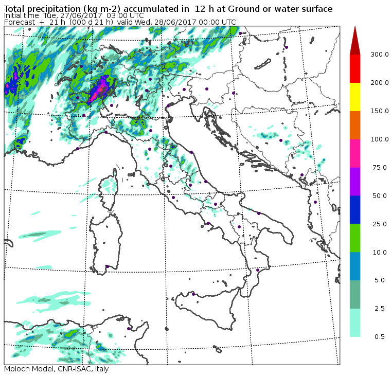

Nella II parte di giornata di domani il modello ci espone la tendenza per della pioggia possibile anche sui settori dell'Italia Centrale. Mentre al Nord le precipitazioni maggiori sembrano estendersi sopratutto sui settori Centro-Orientali.


WeatherRegime- Messaggi : 4401
Data d'iscrizione : 15.10.15
Età : 33
Località : cantù
Re: SW Europe: June 2017 Bay of Biscay WAA DWA CWA 01
Da 2210Gino57 Mar Giu 27, 2017 7:50 pm
verso la mezzanotte ...
divergenza ad alta quota ( vedi il Sounding )
intanto sulla Francia il Fronte Temporalesco
avanza pian piano ...
dalla Riviera del Gulf of Lion fin su a Lyon
una vera ed propria linea di Fulminazioni


visto dal Sat

2210Gino57- Messaggi : 5956
Data d'iscrizione : 29.10.15
Età : 66
Località : CH - 6044 LU 620 m s.l.m. Sicily 96010 Buccheri SR 820 m s.l.m. near M. Lauro Radar Sicily
Re: SW Europe: June 2017 Bay of Biscay WAA DWA CWA 01
Da 2210Gino57 Mar Giu 27, 2017 8:20 pm
here we go again
the show goes on
nostre Latitudini
regioni Alpine ed confini
Alps region and neighboring countries
arriva Low Rasmund
ed il suo Fronte freddo
Bay of Biscay ... France
come detto stasera si fa interessante
mia Citazione
27.06.2017
Attenzione ! ... per il NW Italy
stasera ( 19:00 UTC ... 21:00 h MESZ )
ai Confini tra F ed I in zona Torino
si viene ad formare una Supercell
la direzione è SW - NE ( come ieri 26.06.2017 )
questo Bolide arriva poi fin su nella Svizzera centrale
praticamente dove abito io

da sinistra verso destra


sembra che il Fronte Temporalesco
sulla Francia non abbia intenzione
di indebolirsi ... anzi sembra ...
2210Gino57- Messaggi : 5956
Data d'iscrizione : 29.10.15
Età : 66
Località : CH - 6044 LU 620 m s.l.m. Sicily 96010 Buccheri SR 820 m s.l.m. near M. Lauro Radar Sicily
Re: SW Europe: June 2017 Bay of Biscay WAA DWA CWA 01
Da 2210Gino57 Mar Giu 27, 2017 9:20 pm

questo vuol dire ...
prossimi giorni Pioggia in vista
Rasmund porterà molta Pioggia
ma non solo Pioggia ...
Temporali sono pure inclusi
2210Gino57- Messaggi : 5956
Data d'iscrizione : 29.10.15
Età : 66
Località : CH - 6044 LU 620 m s.l.m. Sicily 96010 Buccheri SR 820 m s.l.m. near M. Lauro Radar Sicily
Re: SW Europe: June 2017 Bay of Biscay WAA DWA CWA 01
Da 2210Gino57 Mar Giu 27, 2017 9:30 pm
se hai interesse
mitteleuropa
here we go again
the show goes on
nostre Latitudini
regioni Alpine ed confini
Alps region and neighboring countries
arriva Low Rasmund
come già postato in un post precedente
per chi non lo avesse notato ( visto )
riecco la somma accumulo Pioggia
dal 27.06.2017 fino al 01.07.2017
per Cantù sui 175 mm
2210Gino57- Messaggi : 5956
Data d'iscrizione : 29.10.15
Età : 66
Località : CH - 6044 LU 620 m s.l.m. Sicily 96010 Buccheri SR 820 m s.l.m. near M. Lauro Radar Sicily
Re: SW Europe: June 2017 Bay of Biscay WAA DWA CWA 01
Da 2210Gino57 Mar Giu 27, 2017 9:35 pm
here we go again
the show goes on
nostre Latitudini
regioni Alpine ed confini
Alps region and neighboring countries
arriva Low Rasmund
NW Italy ... Piemonte
Fulmini su Torino
2210Gino57- Messaggi : 5956
Data d'iscrizione : 29.10.15
Età : 66
Località : CH - 6044 LU 620 m s.l.m. Sicily 96010 Buccheri SR 820 m s.l.m. near M. Lauro Radar Sicily
Re: SW Europe: June 2017 Bay of Biscay WAA DWA CWA 01
Da 2210Gino57 Mar Giu 27, 2017 9:45 pm
here we go again
the show goes on
nostre Latitudini
regioni Alpine ed confini
Alps region and neighboring countries
arriva Low Rasmund
https://meteo4you.forumattivo.it/t168p100-sw-europe-bay-of-biscay-waa-dwa-cwa#19833
NW Italy ... Lombardia
Provincia di Como

2210Gino57- Messaggi : 5956
Data d'iscrizione : 29.10.15
Età : 66
Località : CH - 6044 LU 620 m s.l.m. Sicily 96010 Buccheri SR 820 m s.l.m. near M. Lauro Radar Sicily
Re: SW Europe: June 2017 Bay of Biscay WAA DWA CWA 01
Da 2210Gino57 Mer Giu 28, 2017 6:50 am
here we go again
the show goes on
nostre Latitudini
regioni Alpine ed confini
Alps region and neighboring countries
arriva Low Rasmund

at the beggining of the forecast period
a deep negatively tilted Trough
will stretch from W Ireland through S France
towards the Balearic Sea
at the SW flank of the Trough
a strong Jet Stream with windspeeds
of up to 60 m/s is forecast
with a strong Cyclonic curvature
at the base of the Trough
the base of the Trough will eject NE-wards
crossing N Italy the Alpine range
il resto della synopsis su Estofex
vedi soprattutto la dove è scritto
North Italy W Slovenia NW Croatia
2210Gino57- Messaggi : 5956
Data d'iscrizione : 29.10.15
Età : 66
Località : CH - 6044 LU 620 m s.l.m. Sicily 96010 Buccheri SR 820 m s.l.m. near M. Lauro Radar Sicily
Re: SW Europe: June 2017 Bay of Biscay WAA DWA CWA 01
Da 2210Gino57 Mer Giu 28, 2017 2:15 pm
scusatemi la mia domanda
ma siete tutti Vacanza ?
che Silenzio nel Forum
===
bene ... andiamo sul reale
ecco la situazione attuale
mitteleuropa
here we go again
the show goes on
nostre Latitudini
regioni Alpine ed confini
Alps region and neighboring countries
arriva Low Rasmund
da notare le Isobari
ed soprattutto il Vento ( 300 mb )


ed ecco la immagine Sat


FU B DWD D

Low Rasmund II III

non vedo Low Rasmund I
non so se è un Errore di Tipografia ...
2210Gino57- Messaggi : 5956
Data d'iscrizione : 29.10.15
Età : 66
Località : CH - 6044 LU 620 m s.l.m. Sicily 96010 Buccheri SR 820 m s.l.m. near M. Lauro Radar Sicily
Contenuto sponsorizzato
Pagina 5 di 9 • 1, 2, 3, 4, 5, 6, 7, 8, 9
» cntrl Europe Alps NW Italy: June 2016 see previous Thread
» January 2017: West Europe started cold vs frost
» start of March 2017: Atlantic W Europe Stormy Weather
» Special: Atlantic Train of Lows Bay of Biscay Cyclogenesis
|
|
|


» LMS in India: A learning management system
» Winter 2019: PV - Stratospheric Sudden Warming SSW Europe
» Nowcasting Gennaio 2018
» Scala Ef europea