
 Meteo4you
SW Europe: July 2017 Bay of Biscay WAA DWA CWA 02
Pagina 1 di 2 • 1, 2 
SW Europe: July 2017 Bay of Biscay WAA DWA CWA 02
Da 2210Gino57 Ven Lug 07, 2017 10:35 pm
https://meteo4you.forumattivo.it/t168p200-sw-europe-june-2017-bay-of-biscay-waa-dwa-cwa-01#19929
mitteleuropa
here we go again
the show goes on
roller coaster Weather
yo yo Weather
nostre Latitudini
regioni Alpine ed confini
Alps region and neighboring countries

2210Gino57- Messaggi : 5956
Data d'iscrizione : 29.10.15
Età : 66
Località : CH - 6044 LU 620 m s.l.m. Sicily 96010 Buccheri SR 820 m s.l.m. near M. Lauro Radar Sicily
Re: SW Europe: July 2017 Bay of Biscay WAA DWA CWA 02
Da 2210Gino57 Sab Lug 08, 2017 9:35 am
mitteleuropa
here we go again
the show goes on
roller coaster Weather
yo yo Weather
nostre Latitudini
regioni Alpine ed confini
Alps region and neighboring countries
Bay of Biscay
in zona Bordeaux NW F
ripetere il tutto di nuovo è inutile
ormai lo si sa in questo tipo di Configurazione barica
com è il evolvere della situazione ( funzione )
per farsi convinto vedi i Thread precedenti
a partire dal 10.06.2017 in poi ed precedenti
comunque sia
a strong Westerly mid level Flow
dominates in the corridor from British Isles to Ukraine
A Cut off over Spain travels NEwardly into France
Ridge covers most of the central and E Mediterranean
two large Lows within cold polar Airmass
are located over Iceland and NE Russia
high Theta-E overspreads Europe
in the zone from Spain through France
South central Europe Italy up to Balkan Peninsula
highest shear values overlapping
with unstable Airmass cover Poland W Ukraine and Romania
Alps region
this area lacks any substantial large scale feature
to provide strong synoptic scale lift
however along with intensifying diurnal heating
evapotranspiration and steep lapse rates
NWP Mesoscale models predict a widespread CI
in the afternoon hours over S Germany and W Austria
GFS is more positive and includes whole Alpine area
in the zone of locally lowered Pressure
producing widespread convective precipitation
small to locally moderate instability ( > 1500 J/kg ML CAPE )
and low shear will favour slowly moving Cells
capable of producing heavy precipitation large hail up to 3-4km
and downburst Type severe wind gusts
thanks to wind field interacting with Mountains
a local enhancement in vertical shear and helicity is possible
and thus supercell TStorms cannot be ruled out
Convection should fade in the nighttime hours
along with disappearing instability
approposito di Montagne
ve ne ho pure accennato
in queste situazioni ovvero ( Configurazione barica )
ovunque vi sono Montagne ... in questo caso le Alpi
si vengono ad formare le famose Lee Clouds
bellissime formazioni di Nubi ma avvolte anche pericolose


intanto ( come già spiega Estofex )
nel Nord Atlantico si sono formati
anzi ... si è formato Low Vincent
Low Vincent I ed Low Vincent II
unendosi al già attivo Low Uwe
il Jet Stream è attualmente molto forte
abbiamo un vero ed proprio srtong zonal Flow
2210Gino57- Messaggi : 5956
Data d'iscrizione : 29.10.15
Età : 66
Località : CH - 6044 LU 620 m s.l.m. Sicily 96010 Buccheri SR 820 m s.l.m. near M. Lauro Radar Sicily
Re: SW Europe: July 2017 Bay of Biscay WAA DWA CWA 02
Da 2210Gino57 Sab Lug 08, 2017 9:50 am
mitteleuropa
here we go again
the show goes on
roller coaster Weather
yo yo Weather
nostre Latitudini
regioni Alpine ed confini
Alps region and neighboring countries
per la Svizzera nel tardo pomeriggio sera
red Alert ... cioè Allerta rosso
vedi la Legenda

coinvolto pure tutto il Nord Italia


2210Gino57- Messaggi : 5956
Data d'iscrizione : 29.10.15
Età : 66
Località : CH - 6044 LU 620 m s.l.m. Sicily 96010 Buccheri SR 820 m s.l.m. near M. Lauro Radar Sicily
Re: SW Europe: July 2017 Bay of Biscay WAA DWA CWA 02
Da WeatherRegime Sab Lug 08, 2017 10:38 am

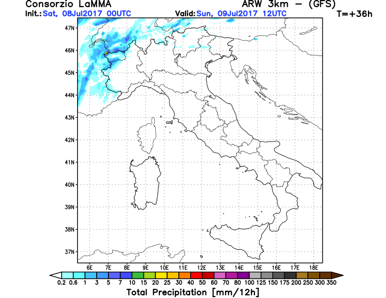
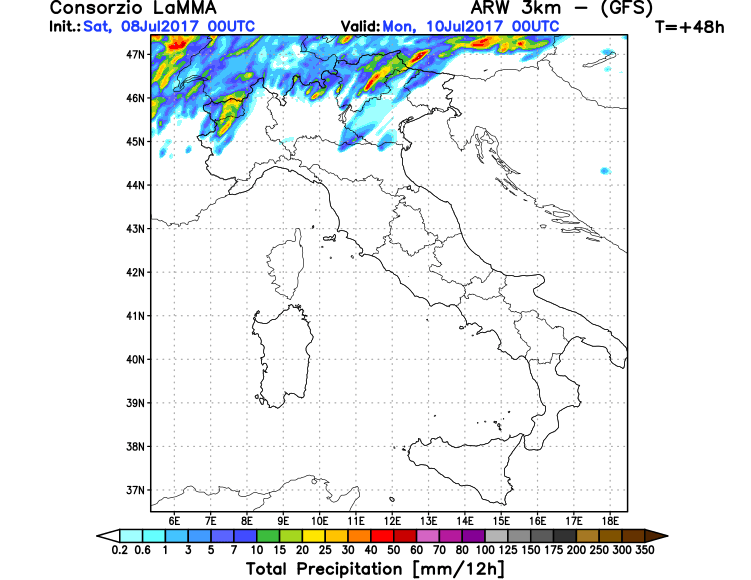
In movimento, molto lento, verso l'W della Francia dal settore Iberico ritroviamo un nocciolo fresco in quota, colui che non fa altro che richiamare aria più calda Continentale verso il Mediterraneo Centrale. Ebbene, i modelli matematici confermano nelle prossime ore come correnti Atlantiche racchiuse in un cavo d'onda andranno ad agganciare il nocciolo fresco in quota raggiungendo l'Europa Centrale. Entro la giornata di domani quindi, specie al Settentrione andremo registrando un calo Gpt e infiltrazioni di aria più fresca ed instabile Atlantica.

Vi allego qualche mappa sulle possibili precipitazioni previste per la giornata di domani che riguarderanno sopratutto i settori Alpini, Prealpini, Pedemontana e localmente in Pianura. Il modello che vede maggiori possibilità d'interessamento pluvio lunga la Pianura è Moloch.
Moloch:


Lam su base Gfs:

WeatherRegime- Messaggi : 4401
Data d'iscrizione : 15.10.15
Età : 33
Località : cantù

2210Gino57- Messaggi : 5956
Data d'iscrizione : 29.10.15
Età : 66
Località : CH - 6044 LU 620 m s.l.m. Sicily 96010 Buccheri SR 820 m s.l.m. near M. Lauro Radar Sicily
Re: SW Europe: July 2017 Bay of Biscay WAA DWA CWA 02
Da 2210Gino57 Sab Lug 08, 2017 10:45 am
Grazie Luca per la Traduzione più specifica
vedi sotto la immagine del Sat ( loop )
cerco di fare il meglio più possibile ( LOL )
2210Gino57- Messaggi : 5956
Data d'iscrizione : 29.10.15
Età : 66
Località : CH - 6044 LU 620 m s.l.m. Sicily 96010 Buccheri SR 820 m s.l.m. near M. Lauro Radar Sicily
Re: SW Europe: July 2017 Bay of Biscay WAA DWA CWA 02
Da WeatherRegime Sab Lug 08, 2017 10:45 am
WeatherRegime- Messaggi : 4401
Data d'iscrizione : 15.10.15
Età : 33
Località : cantù
Re: SW Europe: July 2017 Bay of Biscay WAA DWA CWA 02
Da 2210Gino57 Sab Lug 08, 2017 11:00 am
vedi la ultima immagine sotto sulla destra
le 2 T ... una T in zona Bordeaux
ed una T in zona Barcelona
abbiamo un nuovo Low ... cioè Low Wolf

da notare il Fronte
si estende ( prolunga ) fin giù nel Mar Nero

2210Gino57- Messaggi : 5956
Data d'iscrizione : 29.10.15
Età : 66
Località : CH - 6044 LU 620 m s.l.m. Sicily 96010 Buccheri SR 820 m s.l.m. near M. Lauro Radar Sicily
Re: SW Europe: July 2017 Bay of Biscay WAA DWA CWA 02
Da 2210Gino57 Sab Lug 08, 2017 11:15 am
here we go again
the show goes on
roller coaster Weather
yo yo Weather
nostre Latitudini
regioni Alpine ed confini
Alps region and neighboring countries
Jet Stream


2210Gino57- Messaggi : 5956
Data d'iscrizione : 29.10.15
Età : 66
Località : CH - 6044 LU 620 m s.l.m. Sicily 96010 Buccheri SR 820 m s.l.m. near M. Lauro Radar Sicily
Re: SW Europe: July 2017 Bay of Biscay WAA DWA CWA 02
Da 2210Gino57 Sab Lug 08, 2017 11:30 am
ecco altra immagine per questo Luglio 2017
ve ne ho pure io accenntato come potrebbe evolversi
https://meteo4you.forumattivo.it/t168p175-sw-europe-june-2017-bay-of-biscay-waa-dwa-cwa-01#19919
Seasonal Frcst

per coloro che hanno interesse ( interessati )
di normale abbiamo il Modello della NOAA ( CFSv2 )
ma vi è uno nuovo
a prototype multi System Seasonal Forecast service is now available
2210Gino57- Messaggi : 5956
Data d'iscrizione : 29.10.15
Età : 66
Località : CH - 6044 LU 620 m s.l.m. Sicily 96010 Buccheri SR 820 m s.l.m. near M. Lauro Radar Sicily
Re: SW Europe: July 2017 Bay of Biscay WAA DWA CWA 02
Da 2210Gino57 Sab Lug 08, 2017 12:15 pm
in questi giorni come in altri passati
con simile Configurazione barica
la Temperatura di note
non è scesa sotto i +20°C
quindi Notte Tropicale
quando la Temp di notte rimane sopra i +20°C
viene detto Notte Tropicale ...
attualmente dove abito io +25°C
08.07.2017 ... 12:15:30 h MESZ
2210Gino57- Messaggi : 5956
Data d'iscrizione : 29.10.15
Età : 66
Località : CH - 6044 LU 620 m s.l.m. Sicily 96010 Buccheri SR 820 m s.l.m. near M. Lauro Radar Sicily
Re: SW Europe: July 2017 Bay of Biscay WAA DWA CWA 02
Da 2210Gino57 Sab Lug 08, 2017 12:30 pm
https://meteo4you.forumattivo.it/t171-sw-europe-july-2017-bay-of-biscay-waa-dwa-cwa-02#19940

dove abito io
2210Gino57- Messaggi : 5956
Data d'iscrizione : 29.10.15
Età : 66
Località : CH - 6044 LU 620 m s.l.m. Sicily 96010 Buccheri SR 820 m s.l.m. near M. Lauro Radar Sicily
Re: SW Europe: July 2017 Bay of Biscay WAA DWA CWA 02
Da 2210Gino57 Sab Lug 08, 2017 4:30 pm
mitteleuropa
here we go again
the show goes on
roller coaster Weather
yo yo Weather
nostre Latitudini
regioni Alpine ed confini
Alps region and neighboring countries
dal nulla al Potenziale ...
lo Spettacolo ha inizio ...
2210Gino57- Messaggi : 5956
Data d'iscrizione : 29.10.15
Età : 66
Località : CH - 6044 LU 620 m s.l.m. Sicily 96010 Buccheri SR 820 m s.l.m. near M. Lauro Radar Sicily
Re: SW Europe: July 2017 Bay of Biscay WAA DWA CWA 02
Da 2210Gino57 Sab Lug 08, 2017 5:00 pm
mitteleuropa
here we go again
the show goes on
roller coaster Weather
yo yo Weather
nostre Latitudini
regioni Alpine ed confini
Alps region and neighboring countries
https://meteo4you.forumattivo.it/t171-sw-europe-july-2017-bay-of-biscay-waa-dwa-cwa-02#19932
non solo la Svizzera ma pure nel NW Italy
inizia ad colorarsi di rosso ...
( 08.07.2017 ... 16:45:15 h MESZ )
08.07.2017 ... 16:30:15 h MESZ
guardando nel LapTop
noto che come accennato
il tutto procede puntuale
2210Gino57- Messaggi : 5956
Data d'iscrizione : 29.10.15
Età : 66
Località : CH - 6044 LU 620 m s.l.m. Sicily 96010 Buccheri SR 820 m s.l.m. near M. Lauro Radar Sicily
Re: SW Europe: July 2017 Bay of Biscay WAA DWA CWA 02
Da 2210Gino57 Sab Lug 08, 2017 5:10 pm
mitteleuropa
here we go again
the show goes on
roller coaster Weather
yo yo Weather
nostre Latitudini
regioni Alpine ed confini
Alps region and neighboring countries
https://meteo4you.forumattivo.it/t171-sw-europe-july-2017-bay-of-biscay-waa-dwa-cwa-02#19945

guardate la direzione delle Supercells
vedi mio grafico
https://meteo4you.forumattivo.it/t171-sw-europe-july-2017-bay-of-biscay-waa-dwa-cwa-02#19935
ma pure su estofex lo spiega

2210Gino57- Messaggi : 5956
Data d'iscrizione : 29.10.15
Età : 66
Località : CH - 6044 LU 620 m s.l.m. Sicily 96010 Buccheri SR 820 m s.l.m. near M. Lauro Radar Sicily
Re: SW Europe: July 2017 Bay of Biscay WAA DWA CWA 02
Da 2210Gino57 Sab Lug 08, 2017 6:05 pm
mitteleuropa
here we go again
the show goes on
roller coaster Weather
yo yo Weather
nostre Latitudini
regioni Alpine ed confini
Alps region and neighboring countries
tutta la parte della Svizzera del Nord
da Ginevra fino a Zurigo e poi giù a Innsbruck
sotto una bella Grandinata
quasi sempre downburst ( Wind shear )

2210Gino57- Messaggi : 5956
Data d'iscrizione : 29.10.15
Età : 66
Località : CH - 6044 LU 620 m s.l.m. Sicily 96010 Buccheri SR 820 m s.l.m. near M. Lauro Radar Sicily
Re: SW Europe: July 2017 Bay of Biscay WAA DWA CWA 02
Da 2210Gino57 Sab Lug 08, 2017 6:10 pm
mitteleuropa
here we go again
the show goes on
roller coaster Weather
yo yo Weather
nostre Latitudini
regioni Alpine ed confini
Alps region and neighboring countries
i Tuoni li sento fin quì dove abito io
vedi il grafico
Wind shear

===
Cantù

2210Gino57- Messaggi : 5956
Data d'iscrizione : 29.10.15
Età : 66
Località : CH - 6044 LU 620 m s.l.m. Sicily 96010 Buccheri SR 820 m s.l.m. near M. Lauro Radar Sicily
Re: SW Europe: July 2017 Bay of Biscay WAA DWA CWA 02
Da 2210Gino57 Sab Lug 08, 2017 6:40 pm
here we go again
the show goes on
roller coaster Weather
yo yo Weather
nostre Latitudini
regioni Alpine ed confini
Alps region and neighboring countries

NW Italy ... Piemonte
in zona Alpignano Supercell
2210Gino57- Messaggi : 5956
Data d'iscrizione : 29.10.15
Età : 66
Località : CH - 6044 LU 620 m s.l.m. Sicily 96010 Buccheri SR 820 m s.l.m. near M. Lauro Radar Sicily
Re: SW Europe: July 2017 Bay of Biscay WAA DWA CWA 02
Da 2210Gino57 Sab Lug 08, 2017 6:50 pm
here we go again
the show goes on
roller coaster Weather
yo yo Weather
nostre Latitudini
regioni Alpine ed confini
Alps region and neighboring countries

2210Gino57- Messaggi : 5956
Data d'iscrizione : 29.10.15
Età : 66
Località : CH - 6044 LU 620 m s.l.m. Sicily 96010 Buccheri SR 820 m s.l.m. near M. Lauro Radar Sicily
Re: SW Europe: July 2017 Bay of Biscay WAA DWA CWA 02
Da 2210Gino57 Sab Lug 08, 2017 7:00 pm
here we go again
the show goes on
roller coaster Weather
yo yo Weather
nostre Latitudini
regioni Alpine ed confini
Alps region and neighboring countries
NW Italy
15 km NW from Varallo Sesia
15 km a NO di Varallo Sesia
Supercelll ... possibile direzione
la Prov. di Como
2210Gino57- Messaggi : 5956
Data d'iscrizione : 29.10.15
Età : 66
Località : CH - 6044 LU 620 m s.l.m. Sicily 96010 Buccheri SR 820 m s.l.m. near M. Lauro Radar Sicily
Re: SW Europe: July 2017 Bay of Biscay WAA DWA CWA 02
Da 2210Gino57 Sab Lug 08, 2017 7:05 pm
here we go again
the show goes on
roller coaster Weather
yo yo Weather
nostre Latitudini
regioni Alpine ed confini
Alps region and neighboring countries
https://meteo4you.forumattivo.it/t171-sw-europe-july-2017-bay-of-biscay-waa-dwa-cwa-02#19951

2210Gino57- Messaggi : 5956
Data d'iscrizione : 29.10.15
Età : 66
Località : CH - 6044 LU 620 m s.l.m. Sicily 96010 Buccheri SR 820 m s.l.m. near M. Lauro Radar Sicily
Re: SW Europe: July 2017 Bay of Biscay WAA DWA CWA 02
Da 2210Gino57 Sab Lug 08, 2017 7:25 pm
here we go again
the show goes on
roller coaster Weather
yo yo Weather
nostre Latitudini
regioni Alpine ed confini
Alps region and neighboring countries
Venti

2210Gino57- Messaggi : 5956
Data d'iscrizione : 29.10.15
Età : 66
Località : CH - 6044 LU 620 m s.l.m. Sicily 96010 Buccheri SR 820 m s.l.m. near M. Lauro Radar Sicily
Re: SW Europe: July 2017 Bay of Biscay WAA DWA CWA 02
Da 2210Gino57 Sab Lug 08, 2017 7:55 pm
here we go again
the show goes on
roller coaster Weather
yo yo Weather
nostre Latitudini
regioni Alpine ed confini
Alps region and neighboring countries
eccovi alcuni frames ( loop )
della Goccia fredda over la Spagna
Cut off rotation over Spain


2210Gino57- Messaggi : 5956
Data d'iscrizione : 29.10.15
Età : 66
Località : CH - 6044 LU 620 m s.l.m. Sicily 96010 Buccheri SR 820 m s.l.m. near M. Lauro Radar Sicily
Re: SW Europe: July 2017 Bay of Biscay WAA DWA CWA 02
Da 2210Gino57 Sab Lug 08, 2017 11:30 pm
here we go again
the show goes on
roller coaster Weather
yo yo Weather
nostre Latitudini
regioni Alpine ed confini
Alps region and neighboring countries
eccovi alcuni frames ( loop )
della Goccia fredda over Pirenei
Cut off rotation over central Massif
https://meteo4you.forumattivo.it/t171-sw-europe-july-2017-bay-of-biscay-waa-dwa-cwa-02#19954

loop

Sud Ouest France
Rhone Alpes Bourgogne franche comte Massif central
la nuit dernière et au petit matin des orages modérés
ont éclaté sur le Sud-Ouest de la France
un système orageux assez virulent est formé
à l'Est immédiat de Dijon
en stationnant plusieurs dizaines de minutes
les orages ont ensuite débuté
sur le Massif central en fin d'après midi
attualmente Fulmini nel NE Italy
ma pure in Francia
al Nord di Lyon ed Besncon Fulmini

2210Gino57- Messaggi : 5956
Data d'iscrizione : 29.10.15
Età : 66
Località : CH - 6044 LU 620 m s.l.m. Sicily 96010 Buccheri SR 820 m s.l.m. near M. Lauro Radar Sicily
Re: SW Europe: July 2017 Bay of Biscay WAA DWA CWA 02
Da 2210Gino57 Sab Lug 08, 2017 11:50 pm
here we go again
the show goes on
roller coaster Weather
yo yo Weather
nostre Latitudini
regioni Alpine ed confini
Alps region and neighboring countries
la Odissea non è finita ... to be continued
continuo per Domenica 10.07.2017 ed Lunedi 11.07.2017
severe Weather on Sunday 10.07.2017 and Monday 11.07.2017
Maltempo minaccioso per Domenica 10.07.2017 ed Lunedi 11.07.2017


2210Gino57- Messaggi : 5956
Data d'iscrizione : 29.10.15
Età : 66
Località : CH - 6044 LU 620 m s.l.m. Sicily 96010 Buccheri SR 820 m s.l.m. near M. Lauro Radar Sicily
Contenuto sponsorizzato
Pagina 1 di 2 • 1, 2
» West Europe Alpine regions: July 2016 see previous Thread
» start of March 2017: Atlantic W Europe Stormy Weather
» January 2017: West Europe started cold vs frost
» Special: Atlantic Train of Lows Bay of Biscay Cyclogenesis
|
|
|


» LMS in India: A learning management system
» Winter 2019: PV - Stratospheric Sudden Warming SSW Europe
» Nowcasting Gennaio 2018
» Scala Ef europea